

Posts Tagged: forest health
Just what is a ‘resilient’ forest, anyway?

Study finds resilient, frequent-fire forests have far fewer trees
What does a “resilient” forest look like in California's Sierra Nevada? A lot fewer trees than we're used to, according to a study of frequent-fire forests from the University of California, Davis.
More than a century ago, Sierra Nevada forests faced almost no competition from neighboring trees for resources. The tree densities of the late 1800s would astonish most Californians today. Because of fire suppression, trees in current forests live alongside six to seven times as many trees as their ancestors did — competing for less water amid drier and hotter conditions.
The study, published in the journal Forest Ecology and Management, suggests that low-density stands that largely eliminate tree competition are key to creating forests resilient to the multiple stressors of severe wildfire, drought, bark beetles and climate change.
This approach would be a significant departure from current management strategies, which use competition among trees to direct forest development.
Defining ‘resilience'
But first, the study asks: Just what does “resilience” even mean? Increasingly appearing in management plans, the term has been vague and difficult to quantify. The authors developed this working definition: “Resilience is a measure of the forest's adaptability to a range of stresses and reflects the functional integrity of the ecosystem.”
They also found that a common forestry tool — the Stand Density Index, or SDI — is effective for assessing a forest's resilience.
“Resilient forests respond to a range of stressors, not just one,” said lead author Malcolm North, an affiliate professor of forest ecology with the UC Davis Department of Plant Sciences and a research ecologist with the U.S. Forest Service, Pacific Southwest Research Station. “‘Resistance' is about surviving a particular stress, like fire — but there's a lot more going on in these forests, particularly with the strain of climate change.”
Competitive nature
For fire-adapted forests in the Sierra, managing for resilience requires drastically reducing densities — as much as 80% of trees, in some cases.
“Treatments for restoring resilience in today's forests will need to be much more intensive then the current focus on fuels reduction,” said Scott Stephens of UC Berkeley, a co-author on the paper.
The study compared large-scale historical and contemporary datasets and forest conditions in the southern and central Sierra Nevada, from Sequoia National Forest to the Stanislaus National Forest. It found that between 1911 and 2011, tree densities increased six- to seven-fold while average tree size was reduced by half.
A century ago, both stand densities and competition were low. More than three-quarters of forest stands had low or no competition to slow a tree's growth and reduce its vigor. In contrast, nearly all — 82%-95% — of modern frequent-fire forests are considered in “full competition.”
The study indicates that forests with very low tree densities can be more resilient to compounded threats of fire, drought and other climate stressors while maintaining healthy water quality, wildlife habitat and other natural benefits. Forests burned by high-severity fires or killed by drought lose such ecosystem services.
Wake-up call
The authors say the 2012-2016 drought, in which nearly 150 million trees died from drought-induced bark beetle infestations, served as a wake-up call to the forestry community that different approaches are required to help forests confront multiple threats, not only severe wildfires.
A shift away from managing for competitive forests and toward eliminating competition could allow the few to thrive and be more resilient.
“People have grown accustomed to the high-density forest we live in,” North said. “Most people would be surprised to see what these forests once looked like when frequent surface fires kept them at very low densities. But taking out smaller trees and leaving trees able to get through fire and drought leaves a pretty impressive forest. It does mean creating very open conditions with little inter-tree competition. But there's a lot of historical data that supports this.”
“We think resilient forests can be created, but it requires drastically reducing tree density until there's little to no competition,” said Brandon Collins of UC Berkeley, another co-author on the paper. “Doing this will allow these forests to adapt to future climate.”
Additional co-authors include Ryan Tompkins of UC Cooperative Extension, and Alexis Bernal and Robert York of UC Berkeley.
The study was funded by the National Park Service Pacific West Region, U.S. Forest Service Pacific Southwest Research Station, U.S. Joint Fire Sciences Program, and the UC Agriculture and Natural Resources Division.
New research clarifies impacts of timber harvest on sediment in watersheds
To effectively reduce these adverse effects of harvest, foresters first need to know the precise causes of sediment increases. Historically, researchers investigating the effects of timber harvest on the land have considered two primary drivers: hydrologic changes following timber harvest or fuel reduction that drive sediment transport, and increased sediment supply from ground disturbances and/or mass movements that result from those harvest or fuel reduction activities.
While these causes are tightly linked, little is understood about the relative role each plays in transporting sediment from the watersheds. In other words, which is dominant in increasing sediment delivery and transport: increased streamflow due to greater water availability that can sweep up and transport sediment, or a greater supply of sediment entering the waterway in the first place?
A new analytical approach developed by Safeeq Khan, UC Cooperative Extension specialist in water and watershed sciences at UC Merced, and collaborators now provides valuable insights into this issue, and ways to target effective mitigation strategies.
Published in the Journal of Hydrology last fall, the team's study analyzed long-term (1952-2017) streamflow and sediment data from two adjacent paired watersheds in the H. J. Andrews Experimental Forest in the western Cascades Range of Oregon. One of the watersheds was harvested and replanted in the 1960s, while the second was not disturbed and used as a control.
“The data is from Oregon, but highly relevant for our work in the Sierra Nevada,” said Khan, lead author of the study. “We have tried to quantify the effect of hydrologic changes and increased sediment supply from logging activities on total sediment yield.”

To isolate the relative contributions of streamflow changes and increased sediment supply on sediment transport, Khan and colleagues developed a statistical reconstruction technique to account for the hydrologic changes following harvest.
“This approach allows us to analyze and estimate background sediment production in the treated watershed during the post-treatment period as if the harvest had not occurred, which is remarkable,” said Khan.
The new approach demonstrated that sharp increases in sediment following harvests can be confidently attributed to ground disturbances associated with timber harvest or thinning operations to reduce fuel. Changes in sediment supply overwhelmingly dominate streamflow in terms of contributions to increased sediment in the watershed. Streamflow increases alone led to modest increases in sediment, less than 10%, with the watershed transporting about twice as much total sediment than it would have had the area been left unharvested. This effect diminishes more or less exponentially over time, especially with respect to suspended sediment, as bare areas revegetate, which reduces hillslope sediment supply, and as streamflow returns to pre-treatment levels.
“Once we know the background sediment production, we can easily attribute how much of the increase is due to what mechanisms” said Gordon Grant, a hydrologist with the U.S. Forest Service Pacific Northwest Research Station and co-author on the study.

“Determining that increased sediment in watersheds after harvests is primarily driven by ground disturbance is crucial in targeting mitigation efforts,” explained Khan. “Now, we know that strategies that limit ground disruption – like suspending logs while transporting instead of dragging them, avoiding heavy machinery when and where possible, and mastication and mulching – are likely to be highly effective in reducing sediment yields.”
These changes are most pronounced in the first few years following harvest, but the treated watershed did not return to pre-harvest levels of sediment for two decades, underscoring the long-term effects of harvest on a forest's hydrologic and geomorphic systems.
While clearcutting is no longer practiced on U.S. federal land, it is still the primary timber harvest method used across the globe. Additionally, many other types of forest disturbances such as wildfires, mass tree die-offs, and salvage logging create hydrogeomorphic conditions not too different from clearcutting.
"Our findings provide insights that can help land managers and foresters better target land management and restoration in the future,” said Khan. “We're hopeful that these results will lead to strategies that minimize the long-term impacts and legacies of intense land-use disturbances.”
The full study, titled “Disentangling effects of forest harvest on long-term hydrologic and sediment dynamics, western Cascades, Oregon" is available online in the Journal of Hydrology at https://www.sciencedirect.com/science/article/pii/S0022169419309941?via%3Dihub.
New mobile app identifies hazardous trees for public safety

"Trees are poems that the earth writes upon the sky,” wrote Kahlil Gibran. But trees falling into power lines have sparked catastrophic fires and falling trees have injured nature lovers.
To prevent power outages, PG&E looks for trees near power lines that need to be trimmed or removed. To prevent power outages and other mishaps caused by failing trees, Matteo Garbelotto, UC Cooperative Extension forest pathology specialist at UC Berkeley, has incorporated science into a mobile application that can be used to determine whether a tree presents a hazard and should be removed.
“PG&E was doing tree surveys with pencil and paper,” said Garbelotto, who saw the manual process as fraught with opportunities for error. A paper record needs to be sent to a central collection site where it is transcribed. In the transcription process, mistakes can be made. And there's no way of verifying if a person actually examined the tree to fill out the form.

“Why don't you do a digital survey?” he asked a PG&E tree surveyor. “Using a tablet or phone, the data could be shipped directly, in real time, to the San Francisco office. Using a phone or GPS device, you will know the precise location of the tree and know the worker did the job. If there's a fire, you have proof.”
PG&E Corporation Foundation, the philanthropic arm of the utility, gave Garbelotto a $70,000 grant to develop the app he envisioned for determining which trees are hazards.
“Developed by dedicated UC Berkeley researchers, the tool will provide benefits for other utilities and the forestry industry as they work to create safe and healthy forests. The easy-to-use mobile platform collects data in real time and creates a record that the survey was completed including relevant details like “when,” “where” and “who,” said Stephanie Isaacson, director of community relations for PG&E.
The UC Cooperative Extension tree disease expert created a list of questions that help evaluate tree health. For example, in addition to asking if the tree leaning toward a power line, surveyors are asked, Are there obvious signs of internal decay? Is there a large wound on the tree?
“If a tree has a wound of 5 inches or more, there is a good chance there is significant decay behind the wound,” Garbelotto said. “If there is a mushroom or conk growing on the tree, that portion of the tree is dead and the branch or whole tree may fall down.”
The app, which Garbelotto has dubbed “Evalutree,” can be used for more than powerline safety.

UC Berkeley Ph.D. student Michael Johnson has been using the app to evaluate different species of trees.
“We have just started our third field season using the app on a project for the Department of Defense that quantifies the health and economic value of the oak woodlands on the 100,000-acre Vandenberg Air Force Base,” said Johnson. “We started with coast live oak the first summer, added tanoak the second summer, and have expanded to bishop pine this summer.”
The mobile app has simplified data collection for Johnson, who is in the Forest Pathology and Mycology Lab at UC Berkeley.
“I used pencil and paper studying postfire aspen regeneration on Forest Service land in Northern Arizona in 2012-2013, where I also did my master's work on ponderosa pine decay in 2013-2015,” Johnson said.
He described his undergraduate work collecting data with pencil and paper carried in a tatum, a 8.5-inch by 12-inch metal case with a clipboard, compared with working with the Evalutree phone app.
“Each day would start with making sure that we had all of our data sheets packed in our bulky field tatums,” Johnson said, “making sure our GPS points were preloaded in a separate, expensive GPS device, making sure that our camera had batteries and that we had dry erase markers for our small white board so that we could indicate which plot each photograph belonged to.
“After the fieldwork was complete, we would spend weeks doing data entry, trying to make out the scrawled numbers and notes – smeared with charcoal and raindrops – and sorting and compiling the data, photos and GPS points. It was time-consuming and painstaking, to say the least.”
For his graduate research, Johnson was able to enter data directly into a spreadsheet on a field computer. “At the end of the field work, I would just have to compile the data from the computer, photos from the camera, and GPS points from the Garmin to make a report,” he said.
“Evalutree has changed all of that. Instead of field tatums and multiple bulky devices, I walk out into the field with a lab cell phone. The app has preloaded survey questions, the ability to connect photographs to specific plots, and drops GPS points at each plot and tree that I survey.”

Working in the U.S. Defense Department's sprawling, undeveloped landscapes, Johnson said, “We are often in the field all day without internet or phone connectivity. The app is prepared to meet this challenge and relies on our phone's internal storage and pre-existing GPS functionality to order and store our data with precision accuracy. At the end of the day – when we have returned to civilization and technology – we simply upload all of our surveys for the day and I immediately have my data and reports in multiple formats, including pdf, xls and kml files, at my fingertips.
“Within minutes, I can update my maps to show the exact location of all of the day's surveys, start crunching data in Excel, or print out a report with the photographs from each plot for my boss,” Johnson said.
Garbelotto, the UC Cooperative Extension specialist, would like to make the technology available to cities and companies that manage trees.
“The app can be used by any agency or government that owns or manages a significant number of trees and needs to run surveys on a regular basis to ensure these trees are not at risk of failing, causing property damage or, worse, casualties or injuries to people,” Garbelotto said.
“The surveys can be easily customized for different projects,” he said. “It can be used for campgrounds or parks to calculate the likelihood of a tree failing and likelihood of causing damage. You could have an answer within minutes of submitting the survey.”
For more information about Evalutree, contact Garbelotto.
This story was updated July 21 to add a quote from PG&E.
The Day That The Beetles Invaded the Bohart
Just call it "The Day that the Beetles Invaded the Bohart." That would be the recent open house at the Bohart Museum of Entomology, University of...
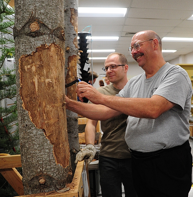
USDA Forest Research entomologist Steve Seybold (foreground) and UC Davis graduate student Corwin Parker peel bark to reveal larvae of bark beetles and wood borers. (Photo by Kathy Keatley Garvey)
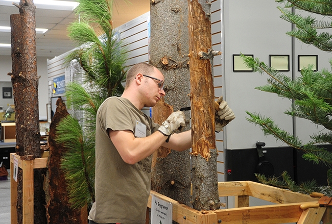
UC Davis graduate student Corwin Parker examines a conifer for beetles. (Photo by Kathy Keatley Garvey)
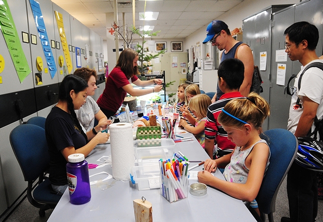
Children flocked to the crafts table to create art focused on bark beetles. (Photo by Kathy Keatley Garvey)

Natalie Seybold (left) works on bark beetle art. In the background is Bohart Museum associate Mai Lundy. (Photo by Kathy Keatley Garvey)
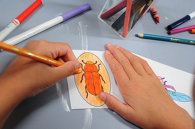
Bark beetle art in the making--this is the work of Natalie Seybold of Davis. She is coloring an outline of a Dendroctonus sp. bark beetle, probably the red turpentine beetle, Dendroctonus valens, or the great spruce beetle, Dendroctonus micans. (Photo by Kathy Keatley Garvey)
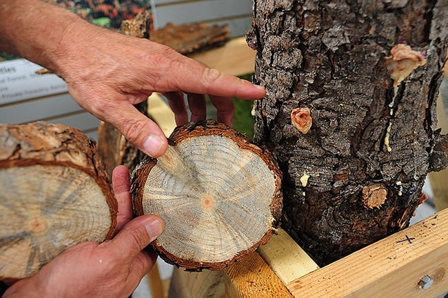
This is staining to a cross section of ponderosa pine, Pinus ponderosa, by a blue-staining fungus carried by the western pine beetle, Dendroctonus brevicomis. In the background: pitch tubes around the entrance holes of western pine beetle, Dendroctonus brevicomis, on the bark surface of ponderosa pine, Pinus ponderosa.(Photo by Kathy Keatley Garvey)
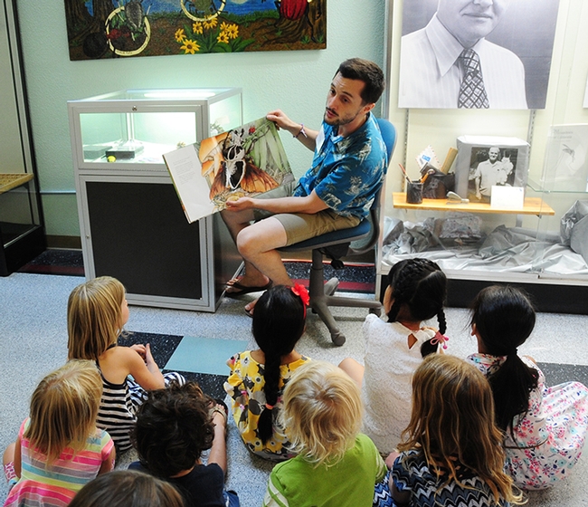
Entomologist Wade Spencer, a UC Davis undergraduate student and Bohart Museum associate, reads a children's book, "Beetle Bedlam." (Photo by Kathy Keatley Garvey)
Bohart Museum Open House: 'Bark Beetle Forest Central'
If you attend the Bohart Museum of Entomology open house from 1 to 4 p.m. on Sunday, Aug. 27, you'll learn all about bark beetles but you probably...
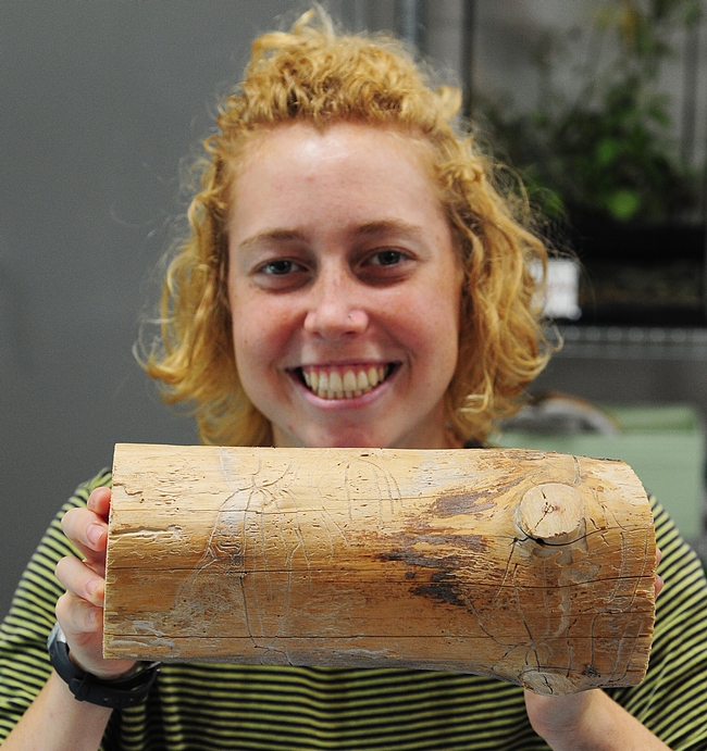
Bohart Museum of Entomology volunteer Riley Gilmartin of Davis shows a chunk of wood with beetle galleries. (Photo by Kathy Keatley Garvey)
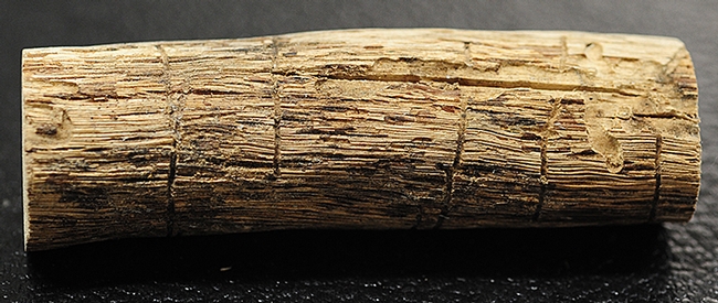
Close-up of beetle galleries. (Photo by Kathy Keatley Garvey)
