Want to report SOD? We’ve got an app for that!
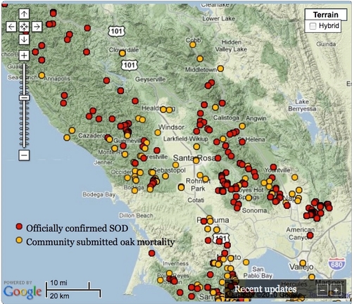
When the great outdoors is your research laboratory, gathering data can be a challenge. To get a broader perspective on the extent of damage caused by sudden oak death, a UC Berkeley Cooperative Extension geographer is using crowd sourcing to enhance her research on the disease that has killed over a million of California’s iconic oak trees since 1995.
Maggi Kelly, UC Berkeley Cooperative Extension specialist, started collecting data from community members through her OakMapper website in 2001. Now she has a mobile application for smartphones
.While out in a park or forest, iPhone users can use the new OakMapper mobile app to report sightings of trees killed by Phytophthora ramorum, the plant pathogen that causes SOD. Onsite, participants can note the symptoms they see, such as seeping, bark discoloration, crown discoloration, dead leaves, shoot die-back, fungus, beetle frass and beetle bore holes.
The OakMapper app, created by scientists in the UC Berkeley Geospatial Innovation Facility, uses the phone's built-in GPS to identify the participant’s location when the data is submitted.
They also can describe the environmental setting, such as residential landscape or natural forest.
“Many of the challenging natural resource problems that we face today – like invasive species, fire, climate change – are large in spatial scale and impact diverse public groups,” said Kelly, director of the UC Berkeley Geospatial Innovation Facility. “Addressing these challenges often requires coordinated monitoring, efficient data collection, and increased communication and cooperation between scientists and citizens.
Science can benefit from your powers of observation. We all benefit by becoming informed about problems such as sudden oak death.
If you are like me, a person who sometimes doesn’t recognize coworkers outside the office, you may choose a spectator role. You can use the app to look at the maps to see where SOD is taking down trees.
For more information about OakMapper and its app, visit oakmapper.org. The OakMapper app can be downloaded for free from the iTunes app store.
I’ve heard of two other apps developed at UC to collect natural resources-related data from other scientists and interested members of the public.
You can use UCLA’s What’s Invasive apps to report locations of top invasive plants and animals, which compete with California’s native fauna and flora. By submitting location data and setting up top invasive lists for your area, you can assist scientists monitoring the spread of the destructive invasive plants and animals. Images and brief descriptions in the app help with identification. The apps are free and available for the Android and iPhone.
Soon you will be able to report roadkill sightings on your iPhone. The UC Davis Road Ecology Center has submitted to the iTunes store an iPhone app for reporting roadkill. Until the app becomes available sometime in January, you can report your observations to the California Roadkill Observation System via the Web at http://roadecology.ucdavis.edu/CROS.html.
Another cool app has been developed by the UC Davis Soil Resource Laboratory to deliver information to scientists, growers and gardeners about the properties of their soil. While standing in the field, the user can receive location-based information on a GPS-enabled cell phone. The app is available for free for iPhone and Android OS platforms.
Which science-related apps are you using? You can share them in the comments section or e-mail me at pskanrice@ucdavis.edu.


