Posts Tagged: Van Butsic
UC ANR scientists receive state cannabis research grants
Several scientists affiliated with the University of California Agriculture and Natural Resources have received grants from the California Bureau of Cannabis Control. The BCC awarded on Nov. 13 a total of $29,950,494 in public university research grants across California for research projects related to the implementation and effect of Proposition 64.
Research proposals had to fall within one of the several specified categories, including public health, criminal justice and public safety, economics, environmental impacts and the cannabis industry.
UC ANR-related cannabis projects and their principal investigators include:
Cannabis industry: Assessment of the location, structure, function, and demographics of licensed cannabis, focusing on geographical price differences, and differential impacts of local Prop 64-related regulations on the competitiveness of licensed businesses – Daniel Sumner, UC Davis professor in the Department of Agricultural and Resource Economics and director of the UC Agricultural Issues Center, $726,816
Economic impacts: Market prices for licensed and unlicensed cannabis and the effects of the current and alternate cannabis tax structures and tax rates on the private and public sectors in California, including government administrative costs and revenues - Sumner, $655,564
Environmental impacts of cannabis cultivation in California as affected by the farm economics of licensed and unlicensed cannabis production, including effects of testing regulations and compliance with the criminal prohibition of unlicensed cannabis - Sumner, $562,240
Assessing environmental impacts of cannabis-related noise and light disturbance to inform management of California wildlife – Justin Brashares, UC Berkeley professor in the Department of Environmental Science, Policy and Management, and Phoebe Parker Shames, graduate student, $489,762
Examining tribal sovereignty over cannabis permitting on native ancestral lands – Jennifer Sowerwine, UC Cooperative Extension specialist; Peter Nelson, professor; and Van Butsic, UC Cooperative Extension specialist; all in the UC Berkeley Department of Environmental Science, Policy and Management, $465,902
Cultivation bans, local control, and the effects and efficacy of Proposition 64 – Christy Getz, UC Cooperative Extension specialist in the UC Berkeley Department of Environmental Science, $328,916
Cannabis and wildfire: Current conditions, future threats, and solutions for farmers – Ted Grantham, UC Cooperative Extension specialist in the UC Berkeley Department of Environmental Science and Butsic, $319,091
Cannabis water-use impacts to streamflow and temperature in salmon-bearing streams – Mary Power, professor in the UC Berkeley Department of Integrative Biology, and Grantham, $314,417
The effect of local cannabis regulation on property prices – Butsic, $270,269
California cannabis workers: perceptions, beliefs, and knowledge of occupational health and industry hazards – Marc Schenker, professor in the UC Davis School of Medicine's Department of Public Health Sciences, $144,949
Related stories:
Cannabis Research Center at UC Berkeley https://rausser.berkeley.edu/news/2020/11/researchers-receive-grants-bureau-cannabis-control.
Cannabis and Hemp Research Center at UC Davis https://cannabis.ucdavis.edu/news/BCCawards
For a list of all public university projects funded by the Bureau of Cannabis Control, visit https://bcc.ca.gov/about_us/documents/media_20201113.pdf.
Reducing wildfire risk includes building communities to coexist with fire
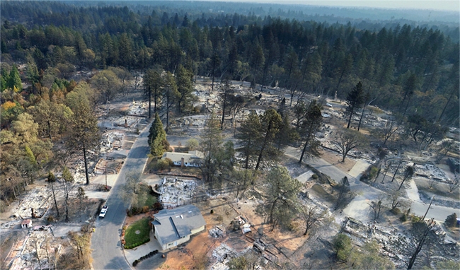
The Camp Fire that destroyed the town of Paradise and other wildfires that have devastated communities in recent years have convinced wildfire experts that Californians need to take more than one approach to coexist with fire.
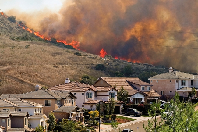
To better protect new houses against wildfire, California has building codes, but where residential communities are built on the landscape and how they are designed are also very important to limit wildfire-related losses, according to University of California Cooperative Extension specialists Max Moritz and Van Butsic.
“Defensible space and vegetation management is important, but in the long term, where and how we build new developments will be equally important for keeping Californians safe,” said Butsic, who studies land use.
To develop their recommendations for reducing wildfire risk for future community development, Moritz, who specializes in wildfire, and Butsic reviewed fire studies and consulted firefighters and community planners.
Their new publication, “Building to Coexist with Fire: Risk Reduction Measures for New Development,” is designed for city planners, fire districts and communities to incorporate community-scale risk reduction measures when building or rebuilding in fire-prone areas.
“There is currently little codified guidance for where and how to build our communities in California, aside from building codes for individual structures and a few requirements for road access and water supplies,” said Moritz, who is based at UC Santa Barbara.
Wildfire consultant and architect David Shew, who retired as a CAL FIRE chief after 31 years, said, “I can state without hesitation that the land use planning principles and design recommendations identified in this study are necessary steps to help increase wildfire resiliency to existing and future communities. Being a first-hand witness to the increasingly destructive nature of wildfires, I can attest to the value and necessity for these improvements to be integrated into our built environment. This should become a much-used reference for every planning and fire official who face wildfire impacts.”
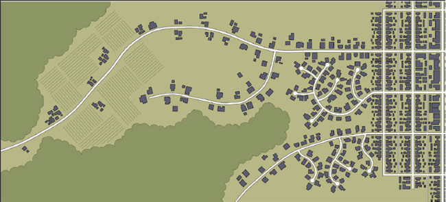
To reduce fire vulnerability of communities, Moritz and coauthor Butsic, who is based at UC Berkeley, recommend including fire professionals and biological resource experts early in the community planning process. They also recommend considering the placement of communities on the landscape, such as near bodies of water and agricultural land, and how they are laid out to minimize exposure to wildfire. Key considerations include defensibility, risk of ignition and ease of evacuating residents.
“This report provides both a robust justification for integrating resilience practices into land use planning and community design, and a toolbox for doing so,” Sarah G.Newkirk, director of disaster resilience with The Nature Conservancy in California. “The risk reduction measures described can be put to use immediately – ideally in combination with each other – both in ongoing wildfire recovery planning, and in local hazard mitigation planning. Furthermore, the report should be a wake-up call to FEMA to think broadly about how best to support wildfire mitigation in California.”
To more efficiently reduce fuel in new communities, Moritz and Butsic write, “The design, maintenance and use of defensible space for fire protection is easier when neighborhoods are developed more densely and are built to stringent fire-resistant building codes.”
In the 31-page publication, they present risk reduction measures for four design contexts:
- landscape setting – engage in strategic planning much earlier, use hazard maps and use major landscape features
- separation from wildfire source—use nonflammable amenities in design, employ safe setbacks on slopes and concentrate on inner side of roadways
- density management – cluster with other homes
- protective infrastructure – harden public facilities and refuges, locate power lines underground and augment water requirements.
They provide examples for each risk reduction measure, along with some discussion of challenges associated with each measure.
“Our hope is that this guidance will be helpful for agency personnel involved in evaluating and approving future development in California,” Moritz said. “Because there is a pressing need for additional housing in California, communities must be built with design principles that make them safer to inhabit and less vulnerable to inevitable wildfires.”
The publication “Building to Coexist with Fire: Risk Reduction Measures for New Development” can be downloaded for free at https://anrcatalog.ucanr.edu/Details.aspx?itemNo=8680.
Cannabis growers asked to comment on permit process
California has legalized marijuana, but commercial cannabis growers have been slow to obtain the required state and local permits. To find out what deters them from complying with new laws, University of California scientists are asking cannabis growers to participate in a survey about their experiences with the regulated market.
“The majority of cannabis farmers are not joining the legal market and we want to know why,” said Van Butsic, UC Cooperative Extension specialist in the Department of Environmental Science, Policy & Management at UC Berkeley. “The objective is to identify barriers to joining the legal market.”
The researchers plan to share the results with policymakers as well as with the cannabis farming community and other researchers.
“Cannabis growers will have an opportunity to tell us what's wrong with the regulatory system so we can advise policymakers on changes they could make to improve compliance,” Butsic said.
Butsic estimates that less than one-third of cannabis growers in Humboldt County have completed the permit process. He says it's difficult to estimate statewide how many cannabis growers are operating illegally because laws vary from county to county and in many parts of the state, local governments don't allow cannabis growing.
One impact from cannabis growers not joining the regulated market is the state receives lower revenues from cultivation taxes.
Beginning on Jan. 1, 2018, two taxes went into effect: a cultivation tax on harvested cannabis that enters the commercial market and a 15% excise tax on purchases of cannabis and cannabis products.
Prop. 64, approved by voters in 2016, stated: “The revenues will provide funds to invest in public health programs that educate youth to prevent and treat serious substance abuse, train local law enforcement to enforce the new law with a focus on DUI enforcement, invest in communities to reduce the illicit market and create job opportunities, and provide for environmental cleanup and restoration of public lands damaged by illegal marijuana cultivation.”
Legalization was projected to create $1 billion annually in new state revenue, but initial tax revenue has been significantly lower. In the Governor's May 1 budget revision, cannabis cultivation and cannabis retail salesrevenues were projected at $288 million in 2018-19 and $359 million in 2019-20.
Compliance is important not only for tax revenue, but also for the environment, Butsic said. Research has shown that illegal cannabis production causes environmental damage, including rodenticide poisoning of forest wildlife.
“We know there are environmental impacts from non-permitted farms,” Butsic said. “The more growers are able to comply, the better off our environment will be.”
The survey can be anonymously filled out online at https://ucanr.edu/sites/compliance until Aug. 1. Cannabis growers who wish to provide more information can volunteer to give the researchers an interview.
CalLands maps cropland ownership across California
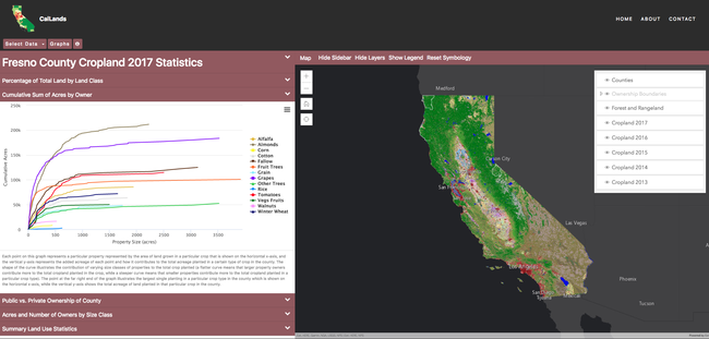
Two UCANR Cooperative Extension specialists have recently launched CalLands, a powerful online tool that can help users understand how land ownership impacts California's croplands.
To build the CalLands' interactive website, Luke Macaulay and Van Butsic — both assistant UC Cooperative Extension specialists based in UC Berkeley's Department of Environmental Science, Policy, and Management — combined satellite-generated maps of land cover created by the U.S. Department of Agriculture with publicly available land ownership records. Next, they anonymized ownership identity and pulled data from all 58 California counties to include parcels of land larger than five acres. The result is a database that features 543,495 privately-owned properties across the state, creating a data-rich map of crops and ownership boundary lines in every county. The interactive map can be filtered by county to display characteristics of land ownership, percentages of private and public ownership, breakdowns by crop-type, and summaries of land-use statistics.
CalLands allows users to explore how crops are distributed within a county or across the state or understand how ownership size impacts how land is used. In a 2017 study on cropland ownership published in California Agriculture, Butsic and Macaulay discovered that the largest five percent of properties account for 50 percent of California cropland. The two created CalLands with the aim of helping a wide variety of stakeholders understand land cover and land use at the county and individual land ownership scale.
“CalLands helps expand people's understanding of the landscape and how farmers across the state are using their land,” Macaulay says.
The website tells the story in visual terms of the location of key crops over time, including water-intensive plants like alfalfa and almonds, and illustrates the locations and acreages of both annual and perennial crops. This information may be useful for those seeking to understand agricultural water use and expansion and change of crops over time. The team hopes that the tool will also help scientists conduct research that is beneficial to many agricultural stakeholders, such as UC Cooperative Extension specialists creating outreach programming, county officials proposing regulations, and resource managers hoping to understand cropland production.
Currently, CalLands features cropland data from 2013-2017, allowing users to toggle between these annual datasets. Macaulay and Butsic plan for future versions of CalLands to include the capability of producing graphs to help users understand how crop planting changes over time as farming shifts and land changes hands. “We look forward to adding more features to CalLands,” Butsic said. “We want to implement changes on the site based on what Californians need.”
February 2019 news clips
Above average rainfall in February benefits strawberry crops in the Central Valley
(ABC 30) Reuben Contreras, Feb. 28
…Above average rainfall in February will help this year's harvest last through October.
"It looks like it is in full bloom right now and it looks like it is going to rain. So we need the water as much as we can right now," said Michael Yang, University of California Cooperative Extension.
He works with small farms and specialty crops in the Hmong community, including a strawberry field in Northeast Fresno near Willow and Behymer.
Yang said the rain will add to the groundwater supply most farmers use to grow their crops plus it will help make the strawberries sweeter.
Ventura County Helps Keep Farming Alive in Southern California
(KCET) Teresa O'Connor, Feb. 27
…Connecting the community to the food system is vitally important for the health of individuals and the survival of local farms, according to Rose Hayden-Smith, Ph.D., who is the editor of the UCFoodObserver.com, an online publication for the University of California (UC). A long-term county resident, Hayden-Smith was previously sustainable food systems initiative leader for UC's Ag and Natural Resources division.
“Everyone eats: everyone is a stakeholder,” says Hayden-Smith. “I would like people to be engaged with the food system, and to advocate for positive change. Think about where your food comes from and ask critical questions about the supply chain. Meet people who are involved in producing, processing, distributing and preparing the food you eat. Honor them with questions about and interest in their work.”
Gene-edited animal creators look beyond US market
(Nature) Heidi Ledford, Feb. 20
…It isn't always easy to pick up a research project and move it to a different country. About ten years ago, difficulties finding funding for his research drove animal geneticist James Murray to move his transgenic goat project from the University of California in Davis to Brazil. The goats were engineered to produce milk that contained lysozyme, an enzyme with antibiotic properties. Murray hoped that the milk could help to protect children from diarrhoea.
https://www.nature.com/articles/d41586-019-00600-4
Newly discovered nematode threatens key crops
(Farm Press) Logan Hawkes, Feb. 20
“The arrival of this nematode (Meloidogyne floridensis) in California is a little surprising — it has the potential to infect many of California's economically important crops,” says UCCE Kern County Advisor Mohammad Yaghmour. “Root samples had been collected from an almond orchard in Merced County last year, and confirmed at the California Department of Food and Agriculture's (CDFA) Nematology Lab as M. floridensis.”
Yaghmour facilitated the second discovery of the nematode in a Kern County orchard a month after the first was uncovered in an almond orchard in Merced County.
https://www.farmprogress.com/tree-nuts/newly-discovered-nematode-threatens-key-crops
Ag Innovations Conference and Trade Show returning to Santa Maria for third event
(Santa Ynez Valley News) Mike Hodgson, Feb. 19
The Ag Innovations Conference and Trade Show will return to Santa Maria for its third event, this time focusing on biologicals, on March 5. The deadline for discounted early registration is next week.
… Considering the growing interest in biologicals and the demand for sustainably produced food, organizers selected topics on biocontrol agents, biostimulants and botanical and microbial pesticides and fungicides for the third conference, said organizer Surendra Dara, UC Cooperative Extension adviser for entomology and biologicals.
“The use of biocontrol agents, biopesticides, biostimulants and other such tools is gradually increasing in our efforts to produce with sustainable practices,” Dara said.
Almond Update: Orchard Recycling Research Showing Strong Results
(AgNet West) Taylor Hillman, Feb. 14
Orchard recycling research has been going on for over 10 years. UC Cooperative Extension Advisor Brent Holtz has been leading the project and said they continue to see positive results. There is an expense that comes with the practice but Holtz said their longest trial is making that cost back in added production.
http://agnetwest.com/almond-update-orchard-recycling-research
NASA tech helps agriculture
(Hanford Sentinel) Julissa Zavala, Feb 13,
…In keeping with the expo's theme, “Harvesting Technology,” NASA Administrator Jim Bridenstine visited the International Agri-Center in Tulare and spoke about how technology originally developed for space exploration is now being repurposed and used to improve numerous aspects of agriculture around the world.
…The measurement, also taken with LIDAR, can be used to calculate precise irrigation needs of plants and crops. Bridenstine said this pilot program, in partnership with the University of California Cooperative Extension and other agencies, is only being used in California.
UC Davis, wine industry cultivate relationship
(Fruit Growers News) Robin Derieux, Feb. 13
Under the hot summer sun of the San Joaquin Valley, just south of Merced, Miguel Guerrero of The Wine Group is trying a new high-wire act. In collaboration with University of California-Davis Cooperative Extension, Roduner Ranch vineyard manager Guerrero is experimenting with Cabernet Sauvignon vines and other varieties elevated by a single wire at 66 inches – plantings that are 2-3 feet higher than the traditional winegrape canopy.
…“The beauty of the high-wire system is that the fruit zone is really defined – a solid wall of grape clusters – and the pruning machine can just zip right alongside the vines,” said Kaan Kurtural, a UC Davis Cooperative Extension viticulture specialist. “We can carry more crop, and with mechanical leaf removal, we get that sun-dappled exposure that feeds the fruit. Less leaf cover means the vines require less water, and the grape quality is much better.”
https://fruitgrowersnews.com/article/uc-davis-wine-industry-cultivate-relationship
There's Still So Much We Need To Learn About Weed—And Fast
(Wired) Matt Simon, Feb. 11
… But late last month, UC Berkeley opened the Cannabis Research Center to start tackling some of these social and environmental unknowns. With its proximity to the legendary growing regions of Northern California, the center can start to quantify this historically secretive industry, measuring its toll on the environment and looking at how existing rules affect the growers themselves. The goal is to create a body of data to inform future policies, making cannabis safer for all.
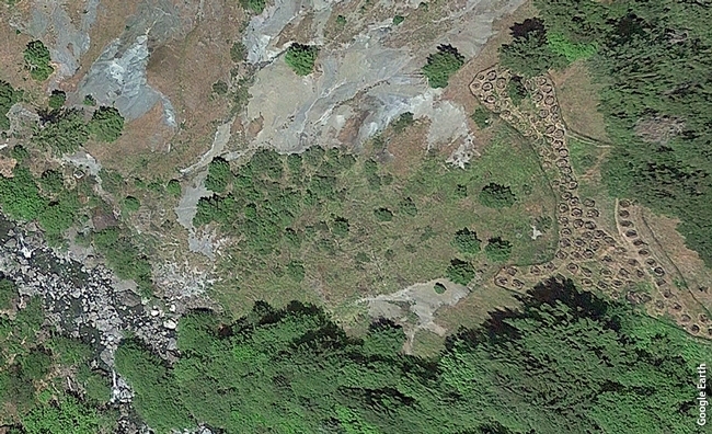
… So for the past few years Van Butsic, codirector of the Cannabis Research Center, and his colleagues have been sifting through satellite images to pinpoint those unaccounted-for farms. “We have an army of undergraduates who look at high-resolution imagery and digitize how big the farms are, how many plants we can see,” Butsic says. Because cannabis plants love light, growers usually keep them out in the open. The researchers still miss many trespass growers, however, who tend to hide their plants in the brush to avoid detection.
https://www.wired.com/story/theres-still-so-much-we-need-to-learn-about-weed
Cultured meat: Good or bad, promise or peril?
(Agweek) By Jonathan Knutson, Feb. 11
…To Alison Van Eenennaam, University of California-Davis Extension specialist in animal biotechnology and genomics, proponents of cell-based meat are "overhyping the environmental benefits" and providing an incomplete, misleading case for it.
https://www.agweek.com/business/agriculture/4568613-cultured-meat-good-or-bad-promise-or-peril
Broomrape Weed Spreads Quickly
(AgNet West) Taylor Hillman, Feb. 8
By the time you see broomrape weed in your fields, it may be too late. There has been a resurgence of broomrape reports over the last decade in California. Retired UC Cooperative Extension Farm Advisor Gene Miyao said although the parasitic weed is far from widespread, it could become so quickly. “The seeds are very small, the growth is primarily underground until it starts sending up shoots and then it very quickly starts setting seed,” he said. “A single seed attached to a tomato plant may send up half-a-dozen shoots, and each shoot might have 1,000 seeds or more.”
http://agnetwest.com/broomrape-weed-spreads-quickly/
New CA Bill Aims to Help Prepare Farmers for Extreme Weather, Changing Climate
(YubaNet) CalCAN, Feb. 7
The state and University of California have made significant investments in research to better understand agriculture's unique vulnerabilities and adaptation strategies to a changing climate, including in the state's recently released Fourth Climate Change Assessment. But not enough has been done to translate climate risks to the farm level and assist farmers in adapting to climate change.
…The bill would also fund trainings for technical assistance providers and agricultural organizations. According to a 2017 survey of 144 University of California Agriculture and Natural Resources staff, 88% of respondents believe it is important to incorporate climate change information into farm extension programs, but only 43% actually do. Respondents cited a lack of access to climate information relevant to farmers and expressed interest in education on technical tools and information resources.
Top administrators from UC ANR visit Imperial Valley
Imperial Valley Press
They were also briefed about UCCE and DREC projects, accomplishments and barriers by the directors, county advisors and CES representatives.
Drought concerns loom for California farmers, ranchers despite recent rain
(KSBY) Dustin Klemann, Feb. 6
Even with the onslaught of rainy weather, the U.S. Drought Monitor states San Luis Obispo County and Santa Barbara County remain in a moderate drought.
On Wednesday, the UC Cooperative Extension held a workshop in Solvang titled “Weather, Grass, and Drought: Planning for Uncertainty.”
“Leave it to a drought workshop to bring the rain,” Matthew Shapero joked. He is a livestock and range advisor for UCCE.
Shapero pointed out a call he received questioning the monitor's accuracy on a local level.
“He said ‘I really don't think the drought monitor accurately reflects what I am seeing on the ground.'”
… “We Californians are constantly accused of not having seasons. We do,” said Dr. Royce Larsen, an advisor of the UCCE. “We have fire, flood, mud, and drought. That's what we live with. And it's getting more and more so every year.”
California legislators honor Summit's Steward Leader Award Winners
(California Economic Summit, Feb. 5
Monday, February 4 was a red-letter day for stewardship in California. Not only was the California Legislature celebrating the Chinese Lunar New Year and “National Wear Red Day” as a symbol of support for women's heart health, but members of both houses also paused to recognize Glenda Humiston and Paul Granillo as recipients of the California Economic Summit's 2018 Steward Leader Awards.
Revealed: how big dairy pushed fattier milks into US schools
(Guardian) Jessica Glenza, Feb. 4
…A nutritionist for the University of California called the idea that chocolate milk could help athletes “preposterous”.
“Milk is a very healthy beverage, it's got protein, calcium, vitamin D – there's a reason we are mammals and grow up drinking milk,” said Lorrene Ritchie, the director of the Nutrition Policy Institute at the University of California. “There's nothing about adding chocolate to it that's going to help an athlete.”
https://www.theguardian.com/us-news/2019/feb/03/revealed-dairy-lobby-fat-milk-trump-sonny-perdue
California's water paradox
(Morning Ag Clips/The Conversation) Faith Kearns and Doug Parker, Feb. 4
These days, it seems everyone is looking for a silver bullet solution to California's drought. Some advocate increasing supply through more storage, desalination or water reuse. Others propose controlling demand through conservation or restriction of water use by urban and agricultural users.
https://www.morningagclips.com/californias-water-paradox
Camp Fire: When survival means shelter
(Mercury News) Lisa Krieger, Feb. 2
“We have to talk about it, as a community, to reduce vulnerability – especially for citizens who don't drive,” said Scott Stephens, co-director of UC-Berkeley's Center for Fire Research and Outreach. “In the Camp Fire, people didn't die because they wanted to stay. They had to stay. All of a sudden, the fire was at their front door step.”
For Australia's policy to work in California, residents must be physically and mental trained, said wildfire specialist Max A. Moritz with UC's Division of Agriculture & Natural Resources. In Australia, which conducts formal training, “there is active participation from homeowners … so both homes and people are better prepared.”
https://www.mercurynews.com/2019/02/02/wildfires-when-survival-means-shelter/


