

Posts Tagged: Sierra
UC ANR research to determine future climate change impacts today
Scientific evidence of a warming climate in California and across the globe is clear, but the impacts on ecosystems and agriculture are still difficult to predict.
Sophisticated computer models are used to forecast future climate. Understanding that temperature and precipitation levels will change in the future does not tell the full story: UC Agriculture and Natural Resources researchers also want real-world experience under those future conditions.
Moreover, some agricultural operations have higher sensitivity to the changes than others. Rangeland forage is particularly sensitive to climate changes since, unlike irrigated agriculture, ranchers rely solely on precipitation. They have no control over how much and when it rains.
“It's tricky business,” said rangeland expert Jeremy James, the director of the UC Sierra Foothill Research and Extension Center in Browns Valley. “It's not easy to forecast. We have to address the uncertainty in a realistic manner.”
")
Discovering climate change impact on rangeland
In order to study different climate projections on rangeland, James and Maggi Kelly, director of the UC ANR Informatics and Global Information Systems special program, have begun development of a research site that will allow scientists to manipulate the temperature and rainfall on sections of rangeland to understand what would happen under predicted weather scenarios.
")
“We need to know how rangelands will respond when conditions change,” James said. “Will we grow more, but dry out earlier? Will we have more medusahead (an undesirable rangeland weed) or more soft chess (a high quality forage)?”
When complete, 16 shelters on steel tracks will be connected to computer systems and hydraulic motors to move them up or down a research plot. The shelters and other equipment will allow scientists to precisely control the amount of precipitation (or irrigation water) that rains onto the plot. Other systems will give researchers control of air temperature.
“This facility isn't designed for one type of research,” James said. “It is designed to conduct a wide variety of research by scientists over the next several decades. With this setup, we can look at the effect of climate change on soil biological communities, soil carbon, insect communities, plant-insect interactions and oak seedling recruitment.”
The research results from the project should provide ranchers and land managers a better understanding of how climate change may impact agriculture and ecosystem function on rangeland while also providing important information on how to minimize impacts of these changes.
Some aspects of the research facility's development are not covered with funding from the National Science Foundation. The scientists are looking for additional support to complete the project.
For more information, contact James at jjjames@ucanr.edu.

Current work underway at the Sierra Foothill Research and Extension Center
The Sierra Foothill REC, a 5,000-acre facility on the Yuba River, has supported research, education and outreach in the Sierra foothills since 1960. Multiple lines of research are being conducted at SFREC. During a recent workshop, scientists from UC Davis, UC Berkeley and UC Cooperative Extension shared a sampling of their work at SFREC.
UCCE livestock and natural resources advisor Dan Macon described a project aimed at helping ranchers make decisions about maintaining a cattle herd when faced with impending drought. Ranchers are reluctant to sell off their cattle even when the near future weather forecast is dire.
“Science tells us you shouldn't feed your way out of a drought,” Macon said. “But you want everything to stay the same. You want to maintain your genetic potential and keep cows that are familiar with the area.”
Working with ranchers, the research project will compare management practices to determine the best way forward when the future looks meteorologically bleak.
“We're assigning cows to a traditional weaning and early weaning groups,” Macon said. “They'll be out on the range from March to early September under different parameters. We're also tying in economics, the value of genetic potential and the value of having cows who know the landscape.”

Research by University of Oregon post doctorate researcher Ashley Shaw is looking into whether compost applied to rangeland will help mitigate climate change by sequestering more carbon, and also benefit forage under drought by increasing the soil's water-holding capacity and improving nutrient delivery.
Preliminary results are promising. A single application of 1/4-inch of compost resulted in forage production that was higher than areas where no amendment was applied and areas that were treated with a chemical fertilizer.
“The biggest impact was under drought shelters,” said Shaw, referring to PVC frames that were covered with plastic during rain events to understand the impact of the treatment under dry conditions. “In the drought plots, the areas where compost was applied are staying green longer.”
A defining research tool at SFREC is a dataset that includes information on monthly rainfall and forage production going back 40 years.
A review of the data shows surprising variations and correlations at the center, where forage production averages 3,000 pounds per acre, but ranges from about 1,000 pounds per acre in 1987, to over 5,000 pounds per acre in 2018, when there was so much growth, “we didn't have enough animals to graze,” James said.
The dataset paints a spectrum of the variation that ranchers across the state must navigate to manage their livestock and rangeland in a way that is profitable and ecologically sound. Research at the Sierra Foothill REC offers invaluable information to help them better understand the ecosystem and make informed decisions.
Art Shapiro: Worst Monarch Season Ever, But Best MIlkweed Season Ever
This year ranks as the worst monarch season he's ever seen in California. But...this year ranks as the best milkweed season he's ever seen in...
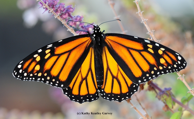
A female monarch butterfly nectaring in a Vacaville pollinator garden. (Photo by Kathy Keatley Garvey)
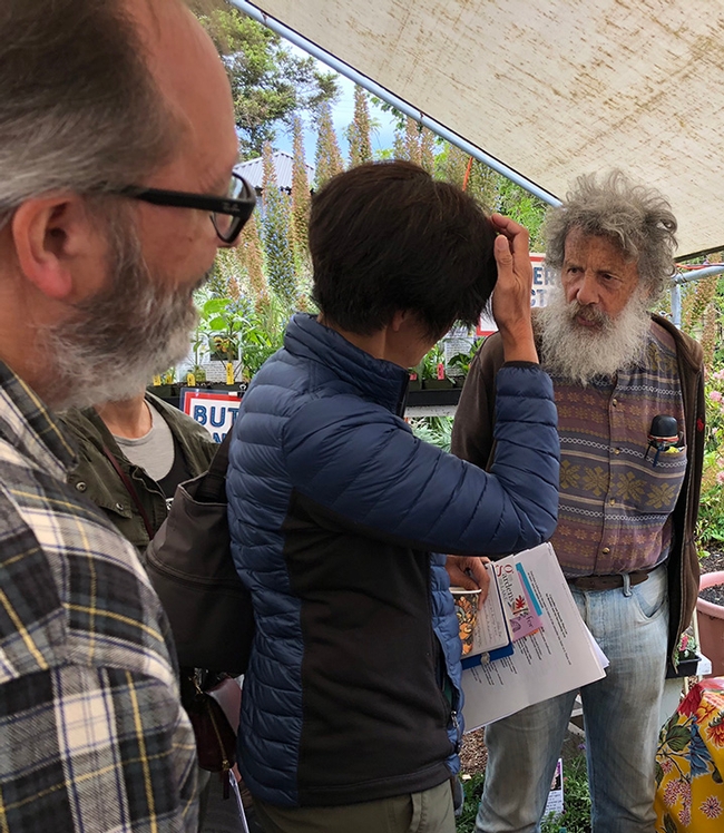
Art Shapiro, UC Davis distinguished professor of evolution and ecology, fields questions at the May 26 Butterfly Summit, held at Annie's Annuals and Perennials, Richmond. (Photo by Kathy Keatley Garvey)
Reevaluate the Sierra Nevada landscape after removing dead trees
This winter, a generous amount of rain and snow has fallen on California, but it can't erase the brown swaths of dead and dying trees in the Sierra Nevada caused by five years of drought and decades of forest mismanagement.
Fire suppression and the harvest of the largest and most resilient trees in the forest led to a large population of weak trees. The prolonged drought further weakened the trees' defenses against native insects. Aerial detection surveys show that more than 102 million trees have died since 2010; more than 62 million died in 2016 alone. Public and private landowners are now struggling to recover from this natural disaster.
UC Cooperative Extension forester and natural resources advisor Susie Kocher recommends dead trees be removed and the landscape reevaluated.
“The dead trees will eventually fall,” Kocher said. “Removing trees around homes and other buildings is especially important for safety. Also, when they fall on the ground they become large fuels on the forest floor, leading to more intense fires.”
")
The cost of removing the trees can be substantial. The State of California is funneling disaster relief funds through California counties, utilities are felling trees that pose a threat to power lines, and local jurisdictions are removing trees that could fall on roads and other public infrastructure. However, most tree removal is the responsibility of private landowners.
When the dead trees are gone, before considering replanting, Kocher suggests Sierra residents carefully assess what has survived.
“There is often a lot of live vegetation remaining,” Kocher said. “Make a map and mark where you find living trees and shrubs and identify them by species and size. If you have a significant number of trees left, you may not need to replant.”
Kocher suggests nurturing the remaining young trees.
“You may want to thin trees out so that available sun and soil moisture are focused on the healthiest individuals. Some watering in the summer may help counter stress caused by increased solar radiation,” she said.
If removing the dead trees leaves the landscape too bare, replanting native conifers is a good strategy. Conifers include pine, cedar and fir trees, but in California's dense forests, firs and cedars – which do well in shady conditions – are beginning to dominate. Replanting may be a time to give native pines – such as Jeffrey, ponderosa and sugar pines – a chance to recover ground.

“The fact that many pines have died does not necessarily mean they are no longer adapted to your location, even with our warming climate,” Kocher said. “There may be a few locations that are less suitable for trees that have grown there in the past, but for most areas, local growing conditions should support native conifers in the near future.”
Native plants and shrubs that died during the drought or were damaged during tree removal will likely come back on their own without replanting. Shrubs and oaks can re-sprout and native herbaceous plants generally store seed in the soil that will grow under native rainfall conditions.
Replanting of trees also gives landowners the chance to shape the landscape for best effect. Kocher offers the following recommendations on replanting trees in natural landscapes:
- Space trees at least 10 feet apart.
- Trees and flammable vegetation should be kept at least 10 feet away from the home, planted sparsely within 30 feet of the home and spaced widely enough in the 30 to 100-food zone so the crowns of the trees will not touch when they are mature. Beyond 100 feet, trees can fill into a more natural looking forest.
- Plant trees at least 10 feet from power lines.
- Do not plant trees within the road right of way to prevent interference with snow clearance, maintenance and construction projects.
- Plant pines where there is a lot of sun. Do not plant sugar pine on the driest sites.
- Avoid planting where the mature trees will block desired views.
Forest and tree health in a time of drought
The fourth winter in a row of disappointing precipitation has triggered a die off of trees in the Sierra Nevada, most of which is now in ‘exceptional drought' status. The US Forest Service conducted aerial monitoring surveys by airplane in April 2015 and observed a large increase in tree mortality in the Southern Sierra (from Sonora south). Surveyors flew over 4.1 million acres of public and private forest land and found that about 20 percent had tree mortality on it, totaling over 10 million dead trees.
The Forest Service found severe mortality in many pine species especially ponderosa pine. On private lands along the foothills of the Sierras, surveyors found extensive areas of dead pines. Large areas of blue and live oak mortality were also suspected though it was too early in the season to be sure.
")
The insects killing trees in the Sierra are all native insects that are multiplying because of drought conditions. Native insects are a necessary part of the forest ecosystem that speed decay of wood back into nutrients, prey on other insects, and provide food for wildlife. They are normally present at low levels and cause tree mortality only in localized areas.
However, drought weakens trees and reduces their ability to withstand insect attacks. Normally trees use pitch to expel beetles that attempt to burrow into the tree through the bark. Weakened trees cannot produce the pitch needed to repel these beetles which are able to enter under the bark and lay eggs. Larvae feed on a tree's inner bark cutting off the tree's ability to transport nutrients and eventually kill it. Attacking beetles release chemicals called pheromones that attract other beetles until a mass attack overcomes the tree. Many beetles also carry fungi that weaken the tree's defenses.
Western pine beetle is one of the main culprits killing pines in the Sierra during this drought. It is a bark beetle, one of a genus of beetles named Dendroctonus which literally means ‘tree-killer'. Adult beetles are dark brown and about a quarter-inch long. Adults bore into ponderosa pines, lay eggs which develop into larvae in the inner bark then complete development in the outer bark. When beetle populations are high, such as during drought periods, even healthy trees may not be able to produce enough pitch to ward off hundreds of beetle attacks.
Western pine beetle often attacks in conjunction with other insects. Other beetles causing tree mortality in Sierra forests include mountain pine beetle, red turpentine beetle, Jeffrey pine beetle, engraver beetles (Ips) and fir engravers. Forests with a higher diversity of tree species are typically less affected because beetles often have a preference for specific tree species. Some species may attack only one tree type. For example Jeffrey pine beetles attack only Jeffrey pine.
.")
The best defense against bark beetles is to keep trees healthy so they are able fight off insects themselves. Widely spaced trees are typically less susceptible to successful attack by bark beetles since they face less competition for moisture, light, and nutrients compared to densely growing and overcrowded trees. Forest health can be promoted by thinning to reduce overcrowding (so each tree has access to more resources) and removing high risk trees during thinning (such as those that are suppressed or unhealthy).
For landscape trees of high value close to a home, watering may be one option to increase tree vigor against bark beetle attacks. Apply about 10 gallons of water for each inch of tree diameter (measured at chest height) around the dripline of the tree once or several times a month during dry weather.
There are some insecticides registered for bark beetle control, but all are preventative only. Carbaryl may prevent attack for up to two years, while pyrethroids can deter attack for up to a year. Spraying can be tricky because the chemical must be applied up to 50 feet up the trunk of the tree usually while standing on the ground. Since misapplication may have toxic consequences, any insecticide must be administered by a licensed pesticide applicator. All applications must follow the label. Though some systemic treatments applied to the soil or inserted into the tree may work in some cases, there is not a lot of documented evidence that they are effective against western pine beetle. No insecticide can prevent tree death once a tree has been successfully attacked.
Author: Susie Kocher, UC Agriculture and Natural Resources Cooperative Extension advisor
King Fire provides learning opportunities

Over a dozen UC Agriculture and Natural Resources (UC ANR) California Naturalists, fire ecology experts, wildlife biologists, resource managers, educators, and artists met at UC Berkeley's Blodgett Forest Research Station and the adjacent El Dorado National Forest April 23 and 24, and not one of them complained about the much-needed deluge of rain and intermittent hail that soaked the group. The weekend's ambitious goal? To dive deeply into a UC California Naturalist Program and California Fire Science Consortium advanced training workshop on the subject of wildfire effects on Sierran mixed conifer forests.
With the 2014 El Dorado National Forest's King Fire as a case study, a mix of lectures, field studies, art, field journaling techniques, and Native American story telling were used to examine land management practices that influence fire behavior and explore how the landscape recovers from fire. UC ANR Cooperative Extension Central Sierra's forestry advisor Susie Kocher and community education specialist Kim Ingram organized and facilitated the workshop.

Blodgett Forest, situated on the Georgetown Divide in El Dorado County, was donated to the University of California in 1933 to provide a research site and practical demonstrations of forestry for students, forest industry, and the public. The adjacent El Dorado National Forest is home to the notorious September-October 2014 King Fire that burned 97,000 acres of forest, including 63,000 acres of public land. Aided by low relative humidity and wind, the fire spread quickly up the steep Rubicon River and surrounding subwatersheds. According to the incident report, approximately 46 percent of the burn area burned at a high and moderate soil burn severity, consuming all organic duff on the soil surface along with leaves and needles on standing live vegetation.
Workshop participants were treated to a lecture and field studies of basic fire ecology concepts by Scott Stephens, professor of fire science at UC Berkeley. Stephens lectured in class, and later demonstrated on a number of wet, lush forested treatment plots in the field, topics ranging from fire policy, fuels management options and objectives, and carbon sequestration to fire suppression consequences, fire behavior and severity, soil stability, and post-fire forest structure. Stephens is a researcher with the Sierra Nevada Adaptive Management Project (SNAMP), a long-term collaborative research project investigating how forest fuels thinning impacts fire behavior, fire risk, wildlife, forest health, and water. Fire is a vital to maintaining healthy California forests and ecosystems and Stephens's work demonstrates that both prescribed fire and its mechanical thinning replacements can successfully change forest structure and fuel loads, resulting in potential overall improvement of forest health. He finds that treated forest stands are more resistant and resilient to high-intensity wildfire and that these treatments have minor to negligible negative impacts on birds and small mammals, understory plant diversity, exotic plant invasions, and insect attack. Current and future research is in part focused on the impact and feasibility of treatments across the landscape.
Also joining participants was Sheila Whitmore from the University of Wisconsin-Madison. Whitmore is the assistant project leader on SNAMP's owl team, which studies how fuel reduction treatments affect California spotted owl survival, forest occupancy, and reproductive success. The California spotted owl is one of three sub-species of spotted owls and the only spotted owl that has not yet been placed on the endangered species list, although its population is widely thought to be declining. Late in the evening, accompanied by Whimore, three nocturnal field technicians, and armed with tools of the trade like bird call whistles and flashlights, participants quietly slogged deep into the forest along the 22-mile system of El Dorado Irrigation District canals, listening for the territorial four-note hoot of the California spotted owl. While the crew eventually found one female owl on the night hike, the owl team has just started surveying breeding territories this spring and are uncertain how and if the owls will be impacted by the King Fire. Modeling efforts and a radio telemetry study seek answers to questions about demography, habitat, individual range size, and foraging preferences, given different levels of severity in burned forests.

Day two of the workshop, under warm sunshine, began with a discussion of Native American fire ecology and traditional stories shared by Kimberly Shiningstar Petree. Petree is a Tumelay Nissenan Miwok, the cultural preservation officer for her tribe, and the founder of the Cosumnes Culture and Waterways, a non-profit dedicated to promoting, preserving, and stewarding Indigenous Culture and waterways of their land. As told by a descendant of the first stewards of the area's forests and a carrier of an ancient oral tradition, the fire stories that Petree shared with the group were both relevant to today's fire management practices, and moving, setting a positive tone for the rest of the day.
Patricia Trimble, El Dorado National Forest's Georgetown district ranger, and Laurie Wigham, illustrator, painter and art teacher, accompanied participants on field activities. Trimble took participants on a road-based tour of the King Fire, demonstrating the effects of low, moderate and severe fire on the landscape. She shared information on consequences of long-term fire suppression, fire impacts, Forest Service strategies for protecting cultural resources, forest replanting and erosion abatement efforts, National Environmental Policy Act regulations, and public perception of fire. More than seven months after the fire, the Forest Service has just opened the burn back up to the public, and the public was out in force mushroom hunting, fishing, and cutting firewood within the high severity areas of the King Fire.
Wigham thoughtfully braided art and field journaling techniques seamlessly into the stops along the way. She shared inexpensive and novel ways to document the landscape in a group or individual setting at difference scales. She offered low-tech tricks to help participants deepen their ability to absorb dense and technical information, observe nature closely and scientifically, and to connect with feelings about a place and time in nature.

Lectures, field study, art, field journaling techniques, knowledge sharing, and Native American story telling: supported by a solid framework of current science topics and research results, they all had their place in this advanced training workshop. Each individual piece of the fire ecology workshop was enriching and informative, and forced participants to move deeper and more thoughtfully into their understanding of the dense topic than they might on their own. The regeneration of the El Dorado National Forest after the King Fire will undoubtedly provide inspiration, research, and education opportunities far into the future.
The UC California Naturalist Program uses a science curriculum, hands-on learning and service to inspire stewardship of the state's natural resources. The public and UC-certified Naturalists alike may sign up for future California Naturalist Advanced Trainings here.
