

Posts Tagged: Sciences
Car fumes, weeds pose double-whammy for fire-loving native plants

Wildflower displays threatened
Northwest of Los Angeles, springtime brings native wildflowers to bloom in the Santa Monica Mountains. These beauties provide food for insects, maintain healthy soil and filter water seeping into the ground – in addition to offering breathtaking displays of color.
They're also good at surviving after wildfire, having adapted to it through millennia. But new research shows wildflowers that usually would burst back after a blaze and a good rain are losing out to the long-standing, double threat of city smog and nonnative weeds.
A recent study led by Justin Valliere, assistant professor in the UC Davis Department of Plant Sciences, found that native wildflowers and other plants that typically flourish following a fire were, instead, replaced by invasive plants on land that received the kind of nitrogen contained in vehicle emissions.

“Many native plants in fire-prone areas rely on fire, and some are entirely dependent on it. Some are even most abundant after a fire,” said Valliere, a UC Cooperative Extension specialist in invasive weed and restoration ecology. “But we found that these fire-following species may be especially vulnerable to the combination of nitrogen pollution and invasive plants.”
That's part of the reason why native plants in these mountains have been declining.
Seeds – banked in the soil and waiting to sprout
The problem faced by native plants can be compared to a drawn-down bank account: Funds withdrawn are not being replaced.
It starts with fire, an important ecological process, Valliere said. Flames burn through plants on the surface and return their nutrients to the soil. Seeds sleeping in the ground wait for the next rain to sprout, then use those nutrients to grow.
“Plant diversity is often highest in growing seasons immediately after a site burns,” he said.
But invading plants have many advantages over native ones. They often sprout earlier, grow faster and create more seeds, all while tolerating drought.
“They're like cheaters,” Valliere said. “They don't follow the same rules.”
Nitrogen, too, is an important piece of every plant's nutrition. They all get a fertilizing boost from nitrogen that floats up in vehicle emissions and falls to the ground. But the invaders use nitrogen and other nutrients to grow faster, winning the race for water and sunlight. As a result, fewer native plants reach maturity, producing fewer seeds that keep their populations thriving.
When the bank balance reaches zero
The 2013 Springs Fire gave Valliere a unique opportunity to study the combined impacts of wildfire and extra nitrogen. He and colleagues from UC Riverside and the National Park Service created test plots in the Santa Monica Mountains where the fire had burned. Then, they added nitrogen to the soil to mimic the amount and type that LA's smog would deposit. Over the study's three years, native plants that typically would have flourished after wildfire instead declined even faster in the plots with added nitrogen.
Native seeds sprouted, but didn't flower. Over time, the soil's bank of seeds drew down.

“Each seed has one chance to flower and reproduce,” Valliere said. “If a seed grows and gets outcompeted, that seed has lost its chance to replenish the seed bank.”
Without the chance to replenish their bank account, native plants will die out, and the whole ecosystem will be thrown out of balance.
“There is inherent value in biodiversity,” Valliere said. “These invasive weeds could prevent the re-establishment of native shrubs after fire, sometimes forever altering the plant community.”
The loss of native plants can have cascading effects on the larger environment, he added. Problems can include the loss of native bees that feed on the flowers, and mudslides when rain makes hillsides unstable.
This problem is likely to repeat in similar areas where biodiversity is highest after wildfires – including parts of the Mediterranean basin, southern Africa and Australia. The addition of city smog “could have serious consequences for the biodiversity of fire-prone ecosystems worldwide,” Valliere warned.
Read the paper, “Nitrogen deposition suppresses ephemeral post-fire plant diversity,” by Justin Valliere, Irina Irvine and Edith Allen.
This article was first published on the UC Davis Department of Plant Sciences website.
Google Weed View? Professor trains computer to spot invasive weed

Algorithm for AI enables low-cost tracking of invasive plant
To manage johnsongrass, a noxious weed that crowds out cotton and sickens horses, farmers have tried herbicides, burning and hand-pulling. Now, researchers at University of California, Davis, have developed a more high-tech weapon against the invasive weed: artificial intelligence and machine learning.
Using photos from Google's Street View database, UC Davis researchers have tracked down over 2,000 cases of johnsongrass in the Western United States for a fraction of the cost and time that it would take to do drive-by or other in-person surveys. They call their tool Google Weed View.
The advancement could help land managers easily and quickly survey for other problem plants.
“Once the model is trained, you can just go and run it on millions of images from Google Street View,” said Mohsen Mesgaran, an assistant professor in the Department of Plant Sciences at UC Davis. “We have huge flexibility, and its capability can be scaled up very quickly.”
The technique can easily be extended to other plant species. All that is needed is to label the new item in Street View photos and train the algorithm to identify that object in the images.
By providing location information, Google Weed View also offers an opportunity to examine how climate affects the growth and spread of weeds and invasive plants at very large scales.
“I think it can be both useful for management and for people with interests in more basic questions in ecology,” Mesgaran said.

A colleague's query
Mesgaran began looking at using Google's photo database of roadways, streets and highways after Kassim Al-Khatib, a professor of Cooperative Extension in the same department, asked if he could survey Western states for johnsongrass.
Al-Khatib studies where johnsongrass grows, ways to manage it and how this perennial has evolved to be so prevalent and resilient. He's also working with scientists at the University of Georgia to decode the genome of johnsongrass, which is one of the top 10 most invasive weeds worldwide.
Johnsongrass can crowd out native plants, harbor pathogens and affect agriculture. It grows up to 7 feet tall with flowers that are green, violet, dark red or purplish brown depending on maturity, according to a UC Statewide Integrated Pest Management Program briefing page.
“Johnsongrass is a major weed not just in California but worldwide,” Al-Khatib said. “It's very difficult to control. It's a problem on vineyards. It's a problem for cultivated crops. It's a problem on orchards.”
Google Weed View allows for rapid, convenient scanning. It is continuously updated via everyday users with compatible cameras and images collected by Google. “Instead of a day of in-person driving, we can use AI to determine if johnsongrass is in a county or not,” Al-Khatib said.

Setting the parameters
To find the weeds, Mesgaran went to Google Street View, which hosts billions of panoramic photos. It didn't take long to find johnsongrass.
“The pictures are really good quality,” he said. “You can see plants and flowers.”
Street View's photos offer a 360-degree view, so in his request Mesgaran set parameters, based on street direction (bearing), to only see the side view. He also specified latitude and longitude, and other factors. To train the deep, or machine learning model, he chose Texas, where johnsongrass is prevalent.
A student sorted through over 20,000 images from that request to find pictures with johnsongrass and drew rectangular shapes around the weeds. They located 1,000 images.
The labeled photos were fed into a computer to train a deep learning algorithm capable of identifying johnsongrass in Google's images. The model was run again to capture potentially more images containing johnsongrass. These additional images were then labeled and used to further refine the model. With each iteration, the algorithm learned and became more accurate.
“This deep learning model was trained by these images,” Mesgaran said. “Once we had a semi-working model, we ran it against about 300,000 images.”
For Al-Khatib's request, researchers focused on 84,000 miles of main roads in California, Nevada, Oregon and Washington states. The team discovered 2,000 locations with johnsongrass.
Google Weed View cost less than $2,000 to purchase the images and teach the model. A traditional car survey to cover the same area would cost an estimated $40,000 in gas, hotel, food and other costs.
“In a matter of months, we came up with 2,000 records and I can do it for the whole U.S.,” Mesgaran said.
Next up? The entire United States.
This story was originally published on the UC Davis College of Agricultural and Environmental Sciences news site.
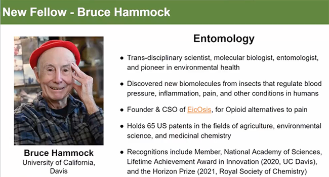
Congrats to Bruce Hammock, Newly Inducted Fellow of California Academy of Sciences
Congratulations to UC Davis distinguished professor Bruce Hammock! Hammock, internationally recognized for discovering a new group of...
A screen shot from UC Davis distinguished professor Walter Leal's video of the California Academy of Sciences' induction of 2023 Fellows.
Congrats to UC Davis Distinguished Professor Lynn Kimsey: Exceptional Faculty Member
Congratulations to UC Davis distinguished professor Lynn Kimsey, director of the Bohart Museum of Entomology, who was recently selected the...
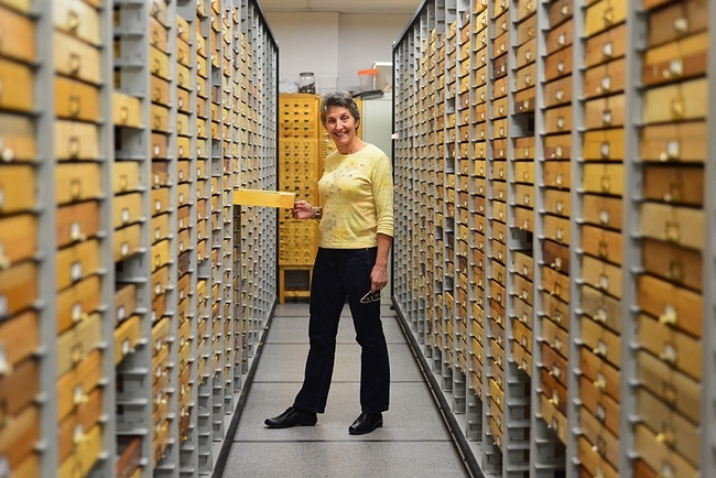
UC Davis distinguished professor Lynn Kimsey, director of the Bohart Museum of Entomology, is the recipient of the 2023 Exceptional Faculty Award from the UC Davis College of Agricultural and Environmental Sciences (CA&ES). (Photo by Kathy Keatley Garvey)
Perfect Timing for Publication of Important Research Paper on Root-Knot Nematodes
Perfect timing. Today, during the 62nd annual international conference of the Society of Nematologists, being held July 9-14 in...
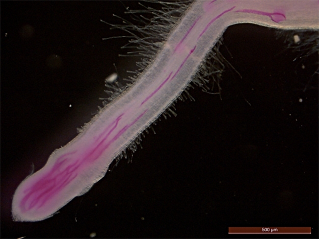
An illustration from the PNAS paper: Rice infected by root-knot nematodes (stained in red). (Illustration by Shahid Siddique)
