Posts Tagged: Yana Valachovic
Lessons from the 2022 wildfire season offer hope
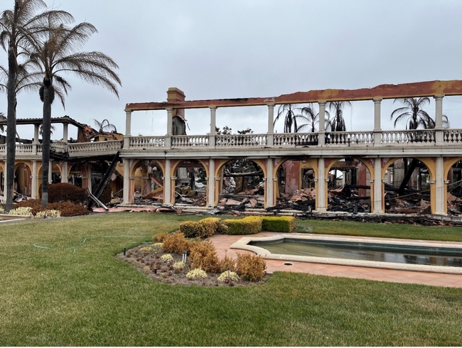
As we prepare for wildfire in 2023, we reflect on what we learned from the 2022 fire season. From a statistical point of view, fewer acres were burned, and fortunately, fewer lives and homes were lost. Less than 400,000 acres were burned, a sevenfold reduction from 2021. On a similar note, less than 1,000 structures were destroyed by wildfire, representing a fourfold reduction from 2021. Those are significant changes, but as I reflect on my experience studying the vulnerabilities in our communities to wildfire, sadly, I need to share that “we're not out of the woods yet,” so to speak, but the formula for success is becoming clearer.
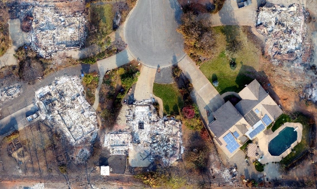
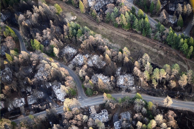
Recently, I worked with great colleagues to evaluate factors contributing to home loss in the town of Paradise during the Camp Fire. In that experience, we learned that the condition of the community of nearby homes has a significant impact on an individual building's survival. In our research, we found that the strongest predictor of loss was attributed to the distance to the nearest destroyed structure, especially if the destroyed building was within 50 feet. That means if a home succumbs to wildfire, it affects the survival of neighboring homes. That lens helped me look for patterns in 2022's wildfire season.
Fences create a wildfire path
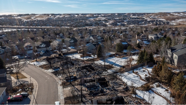
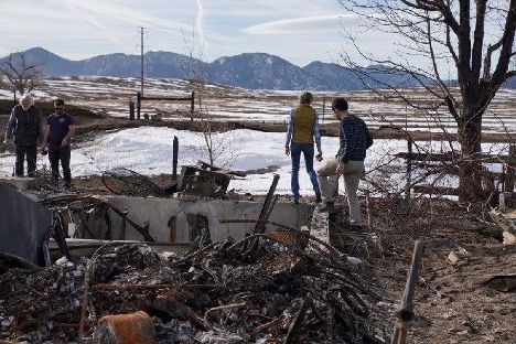
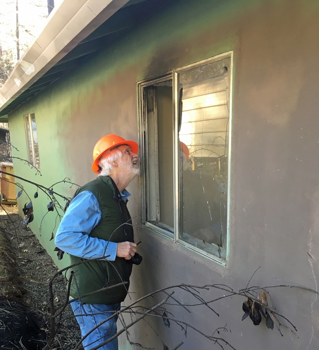
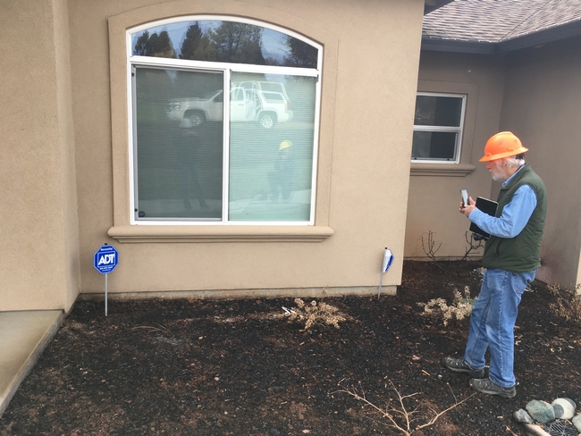
I started 2022 in Boulder, Colorado, at the Marshall Fire. Many may remember that on Dec. 30, 2021, a wildfire challenged our views of when the fire season is deadliest. We were ready to welcome the new year and wildfire was furthest from our minds when several fires ignited during a significant wind event (the cause has still yet to be determined), and within minutes the fire spread to several communities around Boulder. Propelled by gusts of 115 mph, the fire burned 6,000 acres, and when it finally was suppressed by a snowstorm 12 hours later, it left behind 1,084 destroyed structures, including a hotel, a Target store and one shopping center. In January, two weeks after the fire started, I was privileged to accompany scientists from the Insurance Institute for Business and Home Safety (https://ibhs.org/risk-research/wildfire/ ) and UC ANR's Steve Quarles, UC Cooperative Extension advisor emeritus, to search for clues to help understand why some buildings succumbed and others did not.
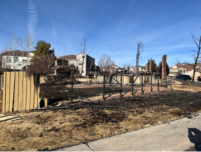
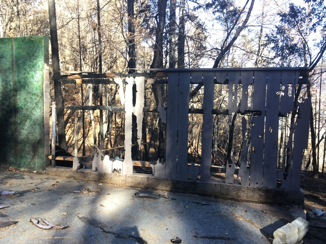
The Marshall Fire burned on the east side of the Rocky Mountains, very different from the forested community of Paradise, where visual privacy between homes can be met through trees. During my visit, I saw that the Marshall Fire quickly spread through the region's grasslands and then to homes via a spaghetti of wooden fences.
These fences offer these communities privacy and backyard protections for kids and pets, but also create a pathway for wildfire to travel between homes. More specifically, the burning grass came into contact with debris and leaves caught at the base of wooden fences, igniting the fence and creating a pathway to bring fire directly to the house. The burning fence ignited surrounding dry ornamental plants and traveled down the fence line bringing flames directly to the house. Once a home ignited, the winds whipped embers from the burning homes to adjacent homes.
I believe that if the fences been upgraded with a 5-foot section of noncombustible materials or a metal gate attaching the fences to the houses, a burning fence would have been much less likely to damage the home.
Fuel reduction works
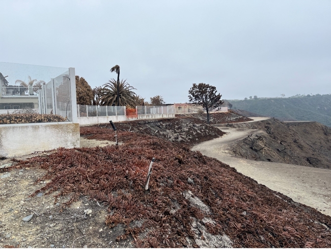
Fast forwarding to May, another fire challenged California's view of the fire season. The Coastal Fire burned on May 11, 2022, in Laguna Niguel near the California coast in Orange County. It was a small fire (200 acres) that burned through dense brush known as chaparral and raced up steep slopes to a network of homes that had been managed to withstand wildfire. In the end, 20 homes were lost. During my visit with my colleague Luca Carmignani, UC Cooperative Extension area fire advisor, we observed that the situation could have been much worse.
The community had completed a significant amount of fuel reduction and prevented flames from directly contacting the homes. This is a huge success that should be celebrated. Their weakness, however, was not preparing for the ember cast that came from the burning chaparral. These homes exhibited the classic effect of having the fire burn to the edge of the community and stop. Then 30 minutes later, fire personnel and the media observed puffs of smoke emanating from the roofs of the homes. So, what was the cause?
Embers found ways inside homes
Embers had penetrated the attic vents, found combustible materials, and fire ignited inside these houses. Fortunately, fire personnel were able to contain the damage to the homes at the exposed edge of the canyon rim and prevent a widespread home-to-home tragedy. Had these communities upgraded their vents to resist embers, the odds that these homes would have survived would have greatly increased.
Defensible space adds protection
The Oak Fire in Mariposa County in July provided another interesting lesson. The fire burned 20,000 acres and took 182 structures. A colleague from CAL FIRE shared that homes that had failed their defensible space inspection before the fire were six times more likely to be lost in the Oak Fire.
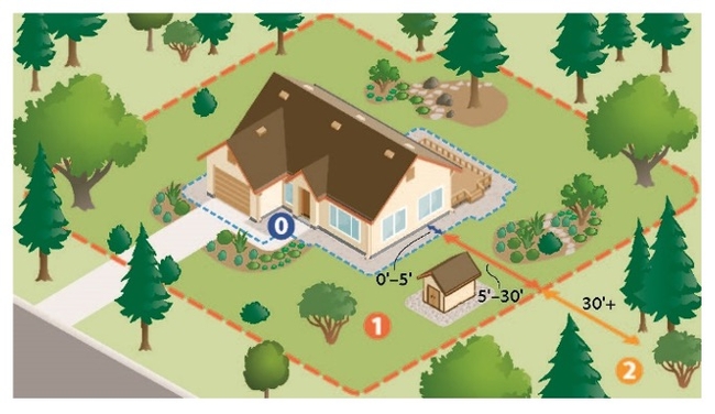
Defensible space is the modification and reduction of combustible materials and vegetation around a home. This required fuel modification provides a safe place for fire personnel to safely stage to address the approaching wildfire, and it also protects the house from catching fire. We all know this is a good practice; perhaps this data can help underscore its importance in building protection.
Wildfire preparation makes a difference
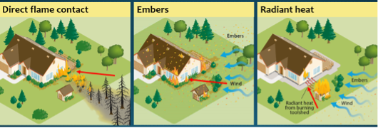
So, what did 2022 tell us? Simply, the details of wildfire preparation matter. Homes are destroyed by one or a combination of exposures: direct flame touching the building, embers penetrating a building through open windows or porous vents, or the radiant heat from the combustion of nearby fuels or homes leading to window breakage.
As Californians, we must prepare for all three types of exposures. We need to break the pathways of continuity from fences and vegetation to our structures. We need to harden our structures to resist heat and embers. We need to reduce fuels around our homes through the creation of defensible space.
To me, home loss to wildfire is predictable; however, the solutions to reducing home loss are within our sights and, with some tenacity and attention to the details, are within our capacities.
Can homes be designed to withstand wildfire?
[This story was originally published Oct. 4, 2021, and updated Dec. 21, 2022]
In 2018, the Camp Fire destroyed nearly 19,000 structures in Northern California, including most of the town of Paradise. The structures left standing by the conflagration provided researchers an opportunity to investigate how housing arrangement – such as the size of the lot, the distance to a neighboring home, and surrounding vegetation – influenced which homes survived. They also looked at whether changes to the California Building Code in 2008, through the addition of Chapter 7A, improved the chances of homes built in the wildland-urban interface to withstand wildfire.
Both housing arrangement and surrounding vegetation likely influenced the survival of homes during an extreme wildfire, according to new research from the USDA Forest Service and the University of California Agriculture and Natural Resources analyzing the Camp Fire aftermath, which will be published Oct. 3 in the journal Fire Ecology.
“Our team found a reason for hope and information that can help Californians, building contractors and policymakers better prepare for future fires,” said co-author Yana Valachovic, University of California Cooperative Extension forest advisor.
The 2008 code, which applied to the city of Paradise, requires the installation of vents that resist flames and embers and other elements that help harden a home to wildfire. This chapter of the California Building Code added requirements for construction materials to California's existing two-zone fuel and vegetation modification guidance, known as “defensible space,” which applies to the vegetation and fuels out to 100 feet from a home.
The researchers found that the age of the home was a significant factor in predicting survival. But the key year wasn't 2008. Improvements in performance happened earlier. Only 11% of single-family homes built in or before 1996 survived, compared with 40% for homes built after 1996. Older homes were, on average, placed closer together and had more overstory tree growth near the home. Overall, the greater the distance between structures, the lower the likelihood of a home being destroyed by the Camp Fire. And the less overstory tree canopy cover, the higher the likelihood of a home surviving.
During a wildfire, structures can be threatened by the flaming front of the fire and by embers that are lofted ahead of the fire and land on fuels such as vegetation or mulch next to the house, igniting new fires. Embers can also enter homes through open windows or vents. Heat radiating from adjacent burning buildings or vegetation can also impact home survival.
In 2022, during a visit to Laguna Niguel after the Coastal Fire, Valachovic saw that defensible space had prevented flames from reaching homes. However, some houses had burned from the inside out after embers penetrated attic vents and ignited combustible materials.
“Despite the unpredictable nature of wildfire, strong associations with home arrangement and overstory vegetation cover indicate home survival is at least somewhat predictable,” said lead author Eric Knapp of the USDA Forest Service. “The silver lining is that this also suggests steps can be taken to substantially improve the odds of homes surviving a wildfire.”
One of the biggest drivers of home loss in the Camp Fire was the heat radiating from the large number of structures that burned. Over 73% of homes destroyed in Paradise had a structure burn within 59 feet. The distance to the nearest destroyed structure or total number of destroyed structures within 328 feet was a primary predictor of home loss.
“Exposure to the heat of a nearby burning structure can break glass in a window, for example. Once the glass is broken, embers or flames can enter the house,” said co-author Steve Quarles, emeritus UC Cooperative Extension advisor and retired chief scientist for the Insurance Institute for Building & Home Safety.
This finding suggests that denser developments, built to the highest standards, may protect subdivisions against radiant heat from a vegetation fire, but density may become a detriment once buildings ignite and radiant heat loads increase as well as the increased potential for direct flame contact.
“This research suggests a strong neighborhood effect, where the condition and proximity of an outbuilding or a neighbor's home can have a significant influence on a building's survival given the radiant heat exposure from a neighboring building burning,” Valachovic said.
Tree canopy cover was also associated with home loss, with a higher probability of home survival where tree cover was moderate or less.
“Trees provide shade, which is important where summers are hot. But to have the amenities trees provide without undue fire hazard, the key is to clean up the leaves and dead wood trees produce,” said Knapp. “This includes keeping roofs, gutters, garden beds adjacent to the structure and spaces under attached decks, free of leaves.”
The researchers detected no significant increase in survival for homes built from 2008 to 2018, under the new building code, compared to homes constructed during an equal time period, 1997 to 2007, immediately preceding the adoption of the new code. Houses built during the last two decades resisted wildfire better than older homes, indicating an overall improvement in common construction standards and the performance of building materials.
“It is important for Californians to understand that homes and immediate surroundings need to be well-maintained to resist embers, survive extended radiant heat exposures and minimize direct flame contact,” Quarles said. “Fortunately, all building codes get better with time and Chapter 7A is no exception – Californians have benefited from it. California's Building Code is reviewed every three years, and it is evolving as new knowledge becomes available based on research and post-fire assessments.”
To enhance wildfire protection at the neighborhood scale, the researchers recommend coordinating efforts with neighbors.
“Because ember ignition of one house can put neighboring houses at risk, it is critical that fuel reduction happens at a community scale. Living with fire means doing all things possible to prevent one's house from catching fire,” said Valachovic.
There are simple actions that homeowners can take to protect their homes.
“From retrofitting with vents that resist ember entry or using tempered glass windows, to the simple things, like not placing bark mulch or woody plants next to homes, and using gutter guards to minimize leaf and needle accumulation in gutters, all will improve the chance of home survival,” Quarles noted. “It is a matter of how we choose to live in this environment.”
“Housing arrangement and vegetation factors associated with single-family home survival in the 2018 Camp Fire, California” by Knapp, Valachovic, Quarles and Nels G. Johnson is published in the journal Fire Ecology at https://fireecology.springeropen.com/articles/10.1186/s42408-021-00117-0.
For more information:
- Steps for hardening houses against wildfire can also be found at the Fire in California website: https://ucanr.edu/sites/fire/Prepare/Building.
- Reducing the vulnerability to buildings to wildfire: vegetation and landscape guidance https://anrcatalog.ucanr.edu/pdf/8695.pdf
Free wildfire publication simplifies understanding fuel-reduction permits on private land
UCCE forest advisor helps landowners, community groups determine best project options
As Californians prepare for another year of drought and an anticipated intense fire season, landowners and organizations across California have been working to reduce forest fuels – flammable woody material – that can endanger their properties and communities.
For many of them, however, their urgent efforts hit a sizable speed bump: a massive rulebook that describes, amid a thicket of other information, the permits required before people can treat or remove fuels – as well as a litany of attached requirements, restrictions and stipulations.
“The California Forest Practice Rules are 410 pages, in font size 6,” said Yana Valachovic, UC Cooperative Extension forest advisor for Humboldt and Del Norte counties and registered professional forester. “Trying to figure out what permit vehicles make sense in the rulebook is not easy even for the experienced professional forester.”
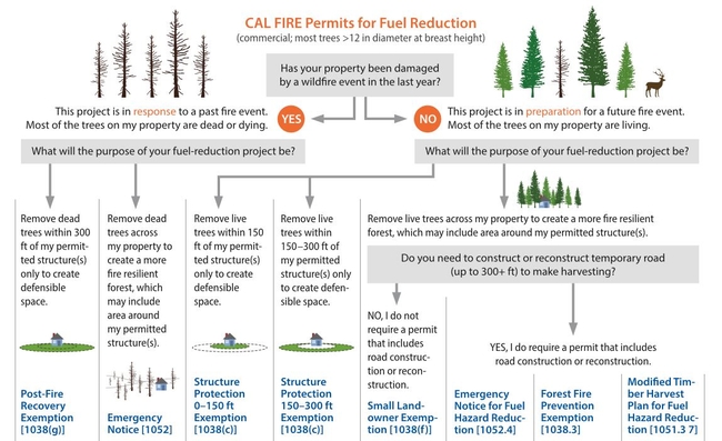
To assist private landowners and community groups in deciphering the rules and determining their most cost-effective options, Valachovic took the lead in writing a new guide, “Planning and Permitting Forest Fuel-Reduction Projects on Private Lands in California,” available as a free resource in the UC Agriculture and Natural Resources catalog.
“We tried to create a system where all the permits are laid out side-by-side, and put in a decision tree framework to help make it easier,” said Valachovic, highlighting the publication's tables that break down the project goals and parameters a permit applicant should think about when weighing their choices.
Considerations include whether the project is pre- or post-wildfire, the location and dimensions of trees targeted for removal, the conditions of the site before and after the project, potential time limits, commercial options, and, crucially, budget constraints – given that the permitting process could comprise up to one-third of total project costs.
A primer for planning and preparation
Chris Curtis, the unit forester for CAL FIRE's Humboldt-Del Norte Unit, said that he and his colleagues are grateful for this new tool and plan to use it as an “over the counter” handout for community members. He added that the charts summarizing timber-harvesting regulations and possible funding sources are especially helpful.
“These give a landowner a starting place to sort through the many commercial timber harvesting documents and fuel-modification project funding source options available,” Curtis said. “A landowner is self-guided to a few options that will seem most appropriate, and this will facilitate a resource professional to assist that person in selecting the most appropriate permitting.”
The publication helps prepare the landowner or community entity (such as Resource Conservation Districts, Fire Safe Councils or other concerned groups) for the types of questions that might come up in preliminary planning conversations with a registered professional forester or RPF.
Just as a homeowner would talk with a contractor before tackling a construction project, landowners and community groups must consult with an RPF, Valachovic said. RPFs have the specialized knowledge of forest practice rules and regulations related to water, air quality and endangered species protections, and the license to file the permitting documents.
“That's what I do in my job: Landowners come to me and we start talking about goals and objectives,” she said. “We start thinking about potential timelines – which goals are short-term, which are long-term – and how we can put an operational plan together to help those landowners achieve their goals.”
Long-term projects, short-term actions
Among the many practical tips outlined in this guide, Valachovic emphasized one in particular: for landowners dipping their toes into fuel reduction for the first time, keep the project “simple and realistic.”
In the short-term, however, Valachovic stressed that the extremely dry conditions across the state make it imperative for Californians to harden their homes, manage the fuels (i.e., landscape plants, stored wood, tall grass, etc.) immediately adjacent to their homes, and devise and review family emergency plans; see UC ANR's Wildfire Preparation page for detailed information and resources.
“There are a lot of immediate actions that people can be doing this year to help mitigate their wildfire risks and prepare for the unexpected,” she said.
In addition to Valachovic, co-authors of “Planning and Permitting Forest Fuel-Reduction Projects on Private Lands in California” are Jared Gerstein of BBW Associates and Brita Goldstein, UCCE staff research associate in Humboldt and Del Norte counties; both are registered professional foresters.
Landscaping with wildfire exposure in mind can protect homes
What can Californians do to improve the chances that their homes will survive a wildfire? Simple actions taken around the home can substantially improve the odds that a home will survive wildfire, according to UC Cooperative Extension advisors.
During wildfire, structures are threatened not only by the flaming front of the fire, but also by flaming embers that are lofted ahead of the fire front and land on fuels such as vegetation or mulch next to the house, igniting new fires. Traditional defensible space tactics are designed to mitigate threats from the flaming front of the fire but do little to address vulnerabilities to embers on or beside a structure.
“Without attention to ember-related risks, defensible space efforts only address a portion of the wildfire threat—especially during wind-driven fires in which embers are the primary source of fire spread,” said co-author Yana Valachovic, UC Cooperative Extension forest advisor in Humboldt and Del Norte counties.
An updated University of California Agriculture and Natural Resources publication describes how embers, radiant heat, and direct flame contact ignite buildings and shares low-cost actions residents can take to create effective defensible space.
“The new publication is up-to-date with the changes in California's defensible space guidance, and it addresses Zone Zero, or the missing ingredient, in defense space,” Valachovic said. “The publication also provides a thoughtful discussion of plant lists and their limitations.”
The odds of a home surviving a wildfire can be substantially improved through careful attention to three things: careful design and maintenance of landscaping; awareness and management of combustible materials on the property such as leaf litter, wood piles and lawn furniture; and incorporation of fire- and ember-resistant construction materials with appropriate installation and maintenance.
“You don't have to spend a lot to protect your home from these wildfire threats,” said Valachovic.
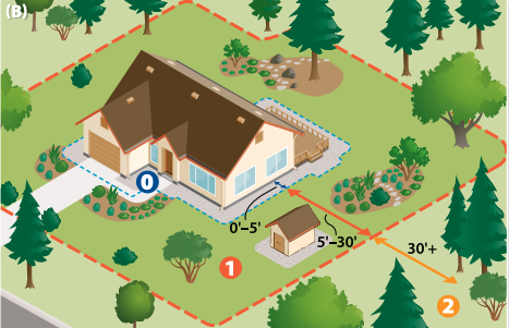
Zone Zero, the area within five feet of the house, is the most vulnerable area around the home, according to the UC Cooperative Extension researchers. “During wind-driven fires, embers are the primary source of fire spread,” Valachovic said.
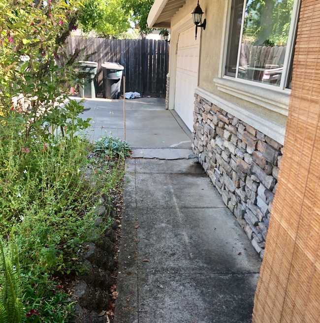
They recommend removing combustible plants, planter boxes, mulches and wood piles within the five-foot perimeter of the house and beneath attached decks.
“While it may be a radical change, clearing the area next to the house will reduce the risk of ember-caused direct flame contact and radiant heat exposure, which are responsible for many home losses,” she said. “Because embers can accumulate at the base of an exterior wall, it is also important to create a six-inch noncombustible zone between the ground and the start of the building's siding.”
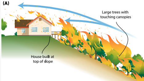
Colorful illustrations in the publication depict the three-zone defensible space strategy and show how spacing out trees on a sloped landscape can prevent fire from climbing from tree to tree to reach a house at the top of the slope.
The 12-page “Reducing the Vulnerability of Building to Wildfire: Vegetation and Landscaping Guidance” is available free for download at https://anrcatalog.ucanr.edu/pdf/8695.pdf.
“Landscaping for fire is part of an overall strategy aimed at reducing risk to the home,” said co-author Steven Swain, UC Cooperative Extension environmental horticulture advisor for Marin and Sonoma counties. “To reduce the risk of home loss, start at the house and work out from there,” he recommended.
Swain, Valachovic and Stephen Quarles, UC Cooperative Extension advisor emeritus, are currently updating a publication on retrofitting houses for wildfire resiliency.
Steps for hardening houses against wildfire can also be found at the Fire in California website: https://ucanr.edu/sites/fire/Prepare/Building.
Climate change is converting cities into 21st century ghost towns
In California, most ghost towns were created when a local industry collapsed. Now, climate change is more often to blame when booming communities whither and die, reported Daniel Cusick in E&E News.
In an eerie horror story released just before Halloween, Cusick wrote about five towns around the nation that have died or are dying from climate-related disasters. Historic Shasta and Helena, Calif., are featured in one of the vignettes.
"Those are two towns that are getting more ghostly," said Yana Valochovich, UC Cooperative Extension forestry advisor in Humboldt and Del Norte counties.
A 19th-century mining town, Shasta City had been a preserved tourist destination in Shasta State Historic Park since 1937 when it was burned in the 2018 Carr Fire, the seventh most destructive wildfire in California history. Helena, a 170-year-old pioneer mining settlement, burned in the Helena Fire of 2017.
There almost certainly will be more "dead towns" as fires consume more of Northern California, Valochovic added.


