

UC Blogs
Rebates Available to Replace Lawns or Install a Smart Irrigation Controller
Want to reduce the amount of water you use in your garden, and help reduce your water bill next summer? There are two rebate programs offered by Solano County Water Agency (SCWA), the Turf Replacement Program and the Smart Irrigation Rebate Program. These rebates are while funding lasts, first come, first serve and this cycle runs through June 30, 2012. You must live in Solano County to qualify.
The Turf Replacement Program offers Solano County homeowners rebates of .60 ? per square foot or up to $600 dollars towards a beautiful new water-wise garden. You must get approval from SCWA before you begin your project, and lawns that are already dead or dying will not qualify. For more information or schedule a pre-inspection call SCWA at 707.455.1113.
Another option is to replace your existing irrigation controller with a Smart Irrigation controller. You can use it with your existing irrigation system and still qualify for $300, $700 or up to $1,000 rebate depending on the size of your station. For more information or to make an appointment for a free landscape survey, call 800-366-6995.
SCWA has other rebate programs for more information: http://solanosaveswater.org/Rebates.html .
How Many Hives for Almond Pollination?
We've been watching the almonds budding and blossoming since late January. They're in full bloom now, but a little ragged by the recent...
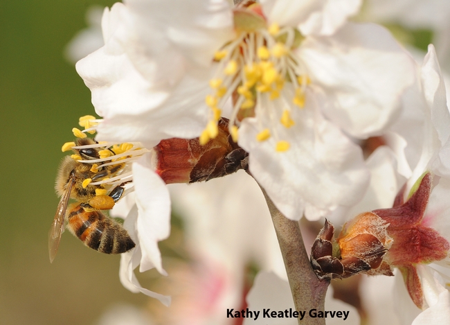
Honey bee working an almond blossom on the grounds of the Harry H. Laidlaw Jr. Honey Bee Research Facility at UC Davis. (Photo by Kathy Keatley Garvey)
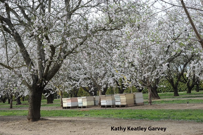
Almond orchard on Pitt School Road, Dixon, Calif. (Photo by Kathy Keatley Garvey)
Yolo County supervisors to preserve farmland
Yolo County supervisors participated in a workshop Tuesday focused on the county's mission to preserve land for agricultural uses, wrote Katherine Jarvis in the Daily Democrat.
The workshop included testimony from agricultural experts, county representatives and the public.
UC Cooperative Extension specialist Louise Jackson of the UC Davis Department of Land, Air and Water Resources testified at the workshop about the importance of preserving Yolo County ag land in light of climate change.
"Climate change is more than just uncertainty about what will happen to crops," she said.
While agriculture contributes to greenhouse gas emissions, maintaining farmland is important, Jackson said.
Higher levels of carbon dioxide can slightly increase total vegetative growth. Lower rainfall from climate change can also create water supply issues while heat waves can cause crop damage.
Jackson said urban and suburban residents need to realize the value of agricultural land.
"It's their backyard," she said.
Yolo County holds workshop aimed at preserving ag land.
Black Salvia
Spring is coming. I can see it, smell it, taste it. Grapes are on sale, and the February heat wave probably got the almond groves blooming. I pray it won't freeze now. I rush out to pick up just one particular plant, and come home with the car stuffed. No sooner do I start planting and repotting, then the heat goes away, I catch a cold, and I am left with the planting blues.
Not to worry. That's what my Internet plant list is for. My first plant to buy this spring will be my long contemplated favorite sage, Salvia discolor. You may know it as Peruvian Black Salvia, or Andean Silver Sage. This delicate love has silvery fuzz all over it's flower bracts, petioles, stems and undersides of leaves. The top of the leaf is bright shiny green. The flowers are so dark purple, they look jet black. The natural color combo strikes me as elegant, spectral and clean. If this plant had a corresponding fairy, she would be the one that lives a little ways up the road from town, sociable, but solitary, you know, the one all the other fairies whisper about. I am going to pamper the heck out of this thing.
Using Lidar to map forest structure and characterize wildlife habitat
UC scientists with the Sierra Nevada Adaptive Management Project (SNAMP) are investigating the uses of Lidar (light detection and ranging) in providing detailed information on how forest habitat is affected by fuels management treatments across a large landscape. Mapping forest structure can illustrate how a forest influences surface hydrology, provides for wildlife and how a forest might burn given certain weather and wind patterns. This research is proving useful in wildlife studies, water quantity and fire modeling and forest planning.
Airborne lidar works by emitting a light pulse from an emitter onboard a plane towards a ground target. A portion of the light is reflected back to the airborne sensor and recorded. The time between sending out the light pulse and receiving it back is converted into distance.

This data, along with GPS information on the aircraft’s exact position and orientation, allows scientists to calculate the height of a target and create 3D maps of the forest vegetation and the bare ground. Raw lidar data is first received as a ‘point cloud’ which consists of millions of points from which meaningful and detailed measurements can be extracted.

Some of the current SNAMP research focuses on developing new methods to detect and delineate individual trees from the point cloud even in complex mixed conifer forests and rugged terrain. The SNAMP spatial team recently published a method that maps all the trees in the forest with 90 percent accuracy. The individual tree identification method identifies trees from the tallest to the shortest and is especially useful in mapping wildlife habitat. For example, the SNAMP spatial and California spotted owl teams collaborated using lidar to map large trees and canopy cover in spotted owl territories. These areas are often hard to identify and map over large areas. Lidar data was used to measure the number, density and pattern of large trees in areas used by the spotted owl. These kinds of data can be used to understand the forest habitat of other bird species and in Pacific fisher research. Below is a short video on the exploration of a lidar point cloud down to an individual tree:
Our goal is to provide methods to map the forest in detail, and thus to help forest managers anticipate the impacts of management decisions.
Images by SNAMP Spatial team/Kelly Labs, UC Berkeley
