

Posts Tagged: Sierra Nevada Adaptive Management Project
Web-based tools' contribution to public participation and natural resource management
Because management projects in contentious natural resource contexts often involve finding reasonable compromise or shared understandings between participants, the success (or failure) of such management is partly about communicating information. Techniques for public participation continue to evolve in order to facilitate a more comprehensive flow of information to, from, and between diverse audiences.
The Internet is part of this evolution: web-based tools provide information exchange between diverse participants and stakeholders about complex environmental systems. But how effective are these tools and do they facilitate the flow of information required in adaptive management? Maggi Kelly, UC Cooperative Extension specialist in the Department of Environmental Science, Policy and Management at UC Berkeley, and Lynn Huntsinger, professor in ESPM at Berkeley, and graduate students Shasta Ferranto, Ken-ichi Ueda and Shufei Lei examined the role of the web in facilitating public participation through a case study - the Sierra Nevada Adaptive Management Project (SNAMP) - a participatory adaptive management project focused on Forest Service vegetation management treatments in California’s Sierra Nevada with a participatory website.
Analyzing three years of website traffic data from Google Analytics, researchers found that the SNAMP website received over 71,000 unique visits from the United States and other countries. Site traffic peaked when quarterly “web updates”- emails sent out to stakeholders with information about the project and any updates - were sent. The data from an email survey conducted by the SNAMP Public Participation Team in 2010 showed that most survey respondents (72.2 percent) had visited the website. Email survey respondents also agreed that the website helped them keep up with SNAMP events, increased information transparency, was easy to use, and was a good source of information. The web also played a small, but important role in public consultation, by providing a discussion board for targeted questions and feedback between the public and SNAMP scientists. However, Internet technology did not actively support the two-way flow of information necessary for mutual learning. It complements, but does not substitute for, face-to-face interactions and public meetings; does not facilitate three-party conversations very well; and has a very small user base to generate sufficient online content and dialogue.

Based on this case study, public participation is most effective when a combination of participatory tools are used, including the web, public meetings, active outreach, and open channels of communication for reaching a broad pool of participants needed for social networking. Website design should be adaptive, and website evolution and maintenance should be budgeted ahead and funded. User needs assessments are necessary to understand how the users collaborate and interact during the life of a project.
Full Reference: M.Kelly, S.Ferranto, K.Ueda, S.Lei, and L.Huntsinger. 2012. Expanding the table: the web as a tool for participatory adaptive management in California forests. Journal of Environmental Management 109: 1-11.
Visualizing the forest
‘Visualizing’ forests from computer and other technological data is common practice in the field of forestry. Forest visualization is used for stand and landscape management and to predict future environmental conditions. Currently, most visualization software packages focus on one forest stand at a time (hundreds of acres), but now we can visualize an entire forest, from ridge top to ridge top. The Sierra Nevada Adaptive Management Project (SNAMP) Spatial Team principle investigators Qinghua Guo, associate professor in the UC Merced School of Engineering; Maggi Kelly, UC Cooperative Extension specialist in the Environmental Science, Policy and Management Department at UC Berkeley; graduate student Jacob Flanagan and undergraduate research assistant Lawrence Lam have created cutting-edge software that allows us to visualize the entire firescape (thousands of acres).

Our new forest visualization software begins by pulling out individual trees from the point cloud. From these individual trees, we extract the tree height and width data. Canopy base height data helps describe the shape of each tree. Then, each individual tree is modeled, and the whole forest is constructed. Visual details such as needles or smooth edges can be added in. This helps to provide a more realistic perspective of the forest than from point clouds alone.


A forested landscape in the Sierra Nevada (left: a photograph taken with a camera) compared to lidar derived virtual forest (right: simulated scene based on the actual location of trees, tree height, and crown size derived from our lidar data, minus the rocks in the lower left-hand corner)
Forest visualization with lidar is useful for helping us understand the complexities in forest structure across the landscape, how the forest recovers from fuels reduction treatments, and how animals with large home ranges might use the forest.
These images, created from lidar data, are still two-dimensional, and thus they lack a sense of depth. To alter that, we have been actively working to bring the created virtual forest into the 3D realm that we are accustomed to seeing in movies or television. Our proposed 3D system relies on stereoscopic imaging to allow individuals to see in 3D. Stereoscopic imaging refers to an optical illusion created by allowing two offset images to be seen by the viewer’s two eyes, independently. The difference in perspective between the left eye and the right eye causes the brain to process the image with depth, which is how current active stereoscopic images are produced in movies or television. By utilizing the fact that the projected forest is virtual, we can then render two offset images to create a new stereoscopic object. From there, a 3D TV easily overlays the two images on top of the other, alternating an image for the left and then right eye, creating an illusion of 3D and depth for the viewer. Again, these visualizations are not of simulated forests, but of our real Sierra Nevada forest, with every tree in the correct place with respect to the other trees, and seen with the correct height.

SNAMP links:
- SNAMP website: http://snamp.cnr.berkeley.edu/
- SNAMP Spatial Team: http://snamp.cnr.berkeley.edu/teams/spatial
- SNAMP Research Briefs (where some of the lidar research has been published): http://snamp.cnr.berkeley.edu/news/categories/research-briefs/
Using Lidar to map forest structure and characterize wildlife habitat
UC scientists with the Sierra Nevada Adaptive Management Project (SNAMP) are investigating the uses of Lidar (light detection and ranging) in providing detailed information on how forest habitat is affected by fuels management treatments across a large landscape. Mapping forest structure can illustrate how a forest influences surface hydrology, provides for wildlife and how a forest might burn given certain weather and wind patterns. This research is proving useful in wildlife studies, water quantity and fire modeling and forest planning.
Airborne lidar works by emitting a light pulse from an emitter onboard a plane towards a ground target. A portion of the light is reflected back to the airborne sensor and recorded. The time between sending out the light pulse and receiving it back is converted into distance.

This data, along with GPS information on the aircraft’s exact position and orientation, allows scientists to calculate the height of a target and create 3D maps of the forest vegetation and the bare ground. Raw lidar data is first received as a ‘point cloud’ which consists of millions of points from which meaningful and detailed measurements can be extracted.

Some of the current SNAMP research focuses on developing new methods to detect and delineate individual trees from the point cloud even in complex mixed conifer forests and rugged terrain. The SNAMP spatial team recently published a method that maps all the trees in the forest with 90 percent accuracy. The individual tree identification method identifies trees from the tallest to the shortest and is especially useful in mapping wildlife habitat. For example, the SNAMP spatial and California spotted owl teams collaborated using lidar to map large trees and canopy cover in spotted owl territories. These areas are often hard to identify and map over large areas. Lidar data was used to measure the number, density and pattern of large trees in areas used by the spotted owl. These kinds of data can be used to understand the forest habitat of other bird species and in Pacific fisher research. Below is a short video on the exploration of a lidar point cloud down to an individual tree:
Our goal is to provide methods to map the forest in detail, and thus to help forest managers anticipate the impacts of management decisions.
Images by SNAMP Spatial team/Kelly Labs, UC Berkeley
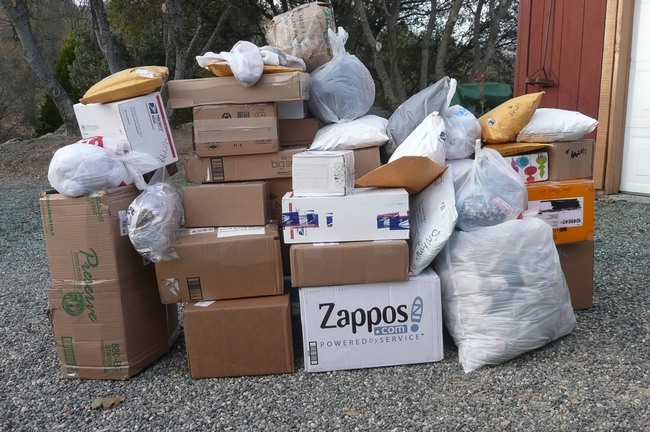
You socked it to us!

The team first got bags of socks from the local high school, and then grocery bags of socks started appearing in a local drop off bin. Soon boxes of socks started arriving by mail. They came from all over California and as far away as Oregon, Nevada, Minnesota, Arkansas and Maryland. The boxes just keep coming: 12 one day, 16 the next, 185 at last count!
During one visit to the post office at Christmas time, we had to roll the bin to the car. Other customers standing in line were trying to hide their envy of our good Christmas fortune!

The wildlife piece of this SNAMP forest study continues, along with our other scientific teams, to look at the effects of the U.S. Forest Service’s thinning projects in the Sierra. These projects are done in our national forests for fire protection and forest health. Our scientific research teams from the University of California are here to look at changes these thinning projects bring to the forest, its water cycle and its wildlife. This collaborative effort is part of state and federal efforts to refine management practices for our beautiful and complex forested ecosystems.
 We have collected years of baseline data and welcome the forest thinning work that has begun this summer in both the southern site near Oakhurst and the northern site near Forest Hill. We will continue to follow the movements of the fisher over the next few years to learn more about their responses to the forest management efforts.
But in the meantime, six newspaper stories and four radio interviews later, we stand in awe of the power of the media and social networks. So, for the many cards, letters and emails we got sharing the stories behind the socks, from the drawers of loved ones who passed away to Earth Day projects for school kids, our wildlife crew is buoyed by your thoughts and support! Our faith in people’s attention to kind details in life is renewed! Thank you!

UC wildlife research team looking for single socks

But what kind of research could go through hundreds of socks a month? After years of experimentation, the research team has determined that socks are the ideal receptacle for hanging fisher bait in trees. The researchers are going through 250 pair a month, at a considerable cost, to create the “chicken in a sock” bait stations.
Besides the cost, chief scientist Dr. Rick Sweitzer is spending too much time in the Wal-Mart checkout line with a cart full of socks.
The scientists don’t need new socks; they would prefer old, unmatched, non-holey ones, something every American has cluttering up their sock drawers. You know the ones!
So, in an effort to reduce, reuse and recycle, the SNAMP wildlife research team is putting out a call for lost and lonely socks. Socks may be delivered or mailed to 40799 Elliott Dr., Oakhurst CA 93644. For more information contact Anne Lombardo at amlombardo@ucdavis.edu. To read more about the research project visit the SNAMP website.
Other wildlife are also attracted to the bait stations:


