

Posts Tagged: flooding
Bodega Marine Lab keeps watch on ocean temperatures

“The physical and chemical environment of the ocean is changing with the climate,” said John Largier of the UC Davis Bodega Marine Laboratory. “This affects ecosystems — like tidal marshes and coral reefs that protect us from storms and flooding.”
The ocean brings stability to the earth’s climate. It heats up and cools down more slowly than the land and the air. With climate change, the ocean absorbs excess heat trapped in the earth’s system by the increased concentration of gases in the atmosphere.
As seawater warms, it expands. The increase in the ocean’s heat content has contributed to one of the most visible effects of global warming — rising sea level. Thermal expansion, along with melting polar ice caps and glaciers, has led to global sea level rise of more than seven inches over the last century.
“When the ocean begins to warm up, then you know that the earth’s climate is changing,” said Largier, a professor in the Department of Environmental Science and Policy. “Even if we stop putting greenhouse gases into the atmosphere right now, the ocean has warmed up, and it will take centuries for it to cool down. People don’t realize that we’ve already made a long-term commitment to climate change.”
At the Bodega Marine Lab, Largier and other scientists are studying the regional impacts of climate change on the waters off California, which include an increase in coastal upwelling. Driven by winds, upwelling pulls cold water and nutrients from the ocean depths to the surface along the shore and contributes to the “marine layer,” the blanket of cool moist air that moderates California temperatures. Largier’s research shows a trend toward stronger winds and an increase in upwelling since 1982, leading to cooler waters off central and northern California.
“Worldwide, the ocean’s surface water is getting warmer, but in California, the ocean is getting colder near shore,” said Largier. “This is intriguing because it shows that climate change is not going to have the same effect everywhere. There will be regional differences.”
This article was condensed slightly from UC Davis “CA&ES Outlook” magazine. Read the full article on page 7.
Read John Largier's scientific advisory group report on how changes in the ocean might affect two valuable marine sanctuaries off the northern California coast: "Climate Change Impacts: Gulf of the Farallones and Cordell Bank National Marine Sanctuaries"
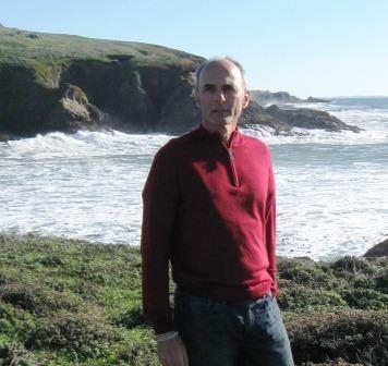
John Largier along the northern California coast. (Photo: Jennifer Sauter/UC Davis)
Jeffrey Mount and the Delta levee blues
Jeffrey Mount, a UC Davis geology professor and the Roy J. Shlemon Chair in Applied Geosciences, was included in “The Sacramento 100” — Sacramento News and Review’s 2010 round-up of the most influential, important and interesting people in Sacramento.
He was joined by an eclectic group of “interesting” characters, so whether being named on the list makes him notorious or famous is up to interpretation.

Jeff Mount
In any case, Mount was aptly described as “the man who knows everything about rivers in a region that owes its existence and continued survival to its rivers and Delta.”
As a local watershed expert and founding director of the UC Davis Center for Watershed Sciences, Mount was frequently called upon in the aftermath of the devastating levee breaks in New Orleans to estimate odds of a similar massive levee failure in the Delta.
The odds aren’t encouraging — Mount predicts a 64 percent chance of massive failure in the next 50 years. And some recent reports from the California Department of Water Resources suggest that is an optimistic estimate.
The strong late December storms sweeping through California had Mount keeping one eye on the levees and another on his kayak. So far this season, Californians have been lucky. But Mount doesn’t expect that luck to hold indefinitely.
The Sacramento-San Joaquin Delta supplies irrigation water for more than a million acres of agriculture in the Central Valley — some of the nation’s most productive farmland — and drinking water for two-thirds of California’s residents. But the levees that hold the Delta together are old and in crisis.
The 1,100-mile system of earthen embankments was built in the late 1800s and early 1900s to reclaim Delta marshland for farms. This creaky system of levees desperately needs a major overhaul. Over time, erosion, seepage and animal burrows have taken their toll. The levees have also been weakened by the gradual sinking of land behind the levees. Many of the Delta islands are now 25 feet below sea level.
Any major levee breach due to storm or earthquake could pull brackish ocean water into the Delta, contaminating irrigation and drinking water supplies and stopping the flow of water to the south and the Bay Area. Infrastructure such as rail lines, highways and gas pipelines would also be impacted.
The big picture of what could go wrong in the case of massive levee failure is scary if you stop and think about it, which has given Mount the name Dr. Doom in some circles. But Mount isn’t one to candy coat the situation. He was once quoted by a reporter that “New Orleans has lost the battle with the inevitable, and we will do the same.”

Jones Tract Flooding, 2004

Flooding in Mossdale, 1997
Invasive reed arundo is choking state waterways

Arundo can grow at a rate of four inches per day and can reach heights of 30 feet. It reproduces and spreads when sections of the stem or root break off and float downstream.
Dense stands of arundo displace native riparian species. The plant requires a significant amount of water, reducing fish, wildlife and people. In addition, clumps of arundo and the soil around their roots can break off, causing streambank erosion. The clumps can also create channel obstructions that lead to flooding.
Arundo is highly flammable and can quickly carry fire along waterways. After a fire, arundo quickly grows back from its roots. With other nearby plants burned by fire, arundo can spread even more quickly, leaving no room for native plants to recover.
Californians can help reduce the spread of arundo by taking the following actions:
- Learn more about arundo, including how to identify it
- Report sightings to local conservation groups
- Join local eradication efforts or help to start one
- If you own land with an arundo infestation, request help and provide access for control efforts
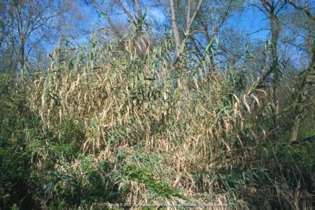
arundo
